How to read a sectional chart for the Part 107 test
The answer
A sectional chart is the FAA's map for pilots flying by sight: a 1:500,000-scale chart, named after a major city in its area, that shows airspace, airports, obstructions and terrain. The Part 107 test uses sectional chart excerpts to ask about airspace, and airspace classification and operating requirements make up 20% of the test's content weights. To read an excerpt, identify the airspace by color and line style, decode the numbers (airspace ceilings and floors are in hundreds of feet above mean sea level), then check the airport data, obstructions and special use airspace.
Last reviewed
Since October 26, 2026, the Part 107 test can include image-based questions not found in the testing supplement (what changed). Memorizing supplement figures is no longer enough: you need to read a chart you have never seen. This guide walks through what to look at, in order, and the topic pages below teach each step on real excerpts.
What a sectional chart is
The FAA's Chart User's Guide describes the Sectional Aeronautical Chart as a chart with the most current data at a scale of 1:500,000, large enough to be read easily by pilots flying by sight under visual flight rules, and named after a major city in its area of coverage. Its legend covers the aeronautical symbols plus drainage, terrain, the contour of the land and elevation. Sectionals are updated every 56 days, so a chart is only as good as its edition.
Source: Chart User's Guide, VFR terms p. 10 (the Sectional); Chart User's Guide, sectional legend p. 23 (charts updated every 56 days); AIM 5-1-1 (sectional charts updated every 56 days)
For a drone pilot the chart answers practical questions: which airspace a site is in, whether that airspace starts at the ground or above you, whether you need ATC authorization, and what tall structures and special areas are nearby. The test asks the same kinds of questions on chart excerpts, so reading the chart is a skill you need on test day and in the field.
What to read first on any excerpt
Work through an unfamiliar excerpt in this order. Each step links to a practice page with worked examples.
-
Airspace colors and line styles
Start with the boundaries around the area in the question. Solid blue sector figures are Class B and solid magenta figures are Class C; a dashed blue line is Class D; a dashed magenta line is a Class E surface area. Under § 107.41 you need prior ATC authorization in Class B, C and D, and within the lateral boundaries of a Class E surface area designated for an airport. You do not need it in Class G, or in Class E that starts at 700 or 1,200 ft AGL. More: Do I need ATC authorization here?
Source: Chart User's Guide, VFR terms p. 16 (right traffic; Class B and Class C altitudes); Chart User's Guide, VFR terms p. 16 (Class D boundary, ceilings and part-time note); Chart User's Guide, VFR terms p. 17 (Class E surface areas, vignettes, Class G); 14 CFR 107.41 (operation in certain airspace)
-
Sector blocks
Inside Class B and Class C, each piece of airspace carries two numbers stacked like a fraction: the ceiling on top, the floor below, both in hundreds of feet MSL. So 100 over 30 is a ceiling of 10,000 ft MSL over a floor of 3,000 ft MSL. SFC means the sector reaches the ground, and a T ceiling on a Class C block means up to, but not including, the floor of the Class B above it. Only the sector you are actually inside, from its floor to its ceiling, counts. More: How to read Class B and Class C sector blocks
Source: Chart User's Guide, VFR terms p. 16 (right traffic; Class B and Class C altitudes); 14 CFR 107.41 (operation in certain airspace)
-
Class D boxes
The ceiling of Class D sits in a dashed blue box, in hundreds of feet MSL: [36] is 3,600 ft MSL, and a minus sign, as in [-45], means from the surface up to, but not including, 4,500 ft MSL. A star after the tower frequency in the airport data means a part-time tower; when a part-time Class D is not in effect it becomes a Class E surface area or Class G, as the Chart Supplement states. Only a reversion to Class G removes the need for authorization. More: Class D on a sectional chart
Source: Chart User's Guide, VFR terms p. 16 (Class D boundary, ceilings and part-time note); Chart User's Guide, VFR terms p. 15 (airport data: elevation, runway length, CT, star, CTAF); AIM 3-2-5 (Class D airspace; part-time surface areas); AIM 3-2-5 (Class D when the tower is closed)
-
Class E shading
Unless the chart shows otherwise, Class E starts at 1,200 ft AGL. A magenta vignette, a soft shaded band, marks where it starts lower, at 700 ft AGL; a blue vignette marks a floor other than 700 ft next to uncontrolled airspace, typically 1,200 ft AGL. Below the Class E floor is Class G. Do not confuse the soft shading with the dashed magenta line, which is Class E from the surface. More: Class E and Class G on a sectional
Source: Chart User's Guide, VFR terms p. 17 (Class E surface areas, vignettes, Class G); AIM 3-2-6 (Class E transition areas: 700 ft and 1,200 ft AGL); Remote Pilot Study Guide ch. 2 (Class G airspace)
-
Airport symbols and data blocks
Blue airport symbols and text mean a control tower; magenta means none. The data block gives the name and identifier, CT and the tower frequency (a star after it means part-time), and a line with the field elevation in feet, the lighting code and the longest runway in hundreds of feet. The frequency followed by a circled C is the CTAF. More: How to read an airport data block
Source: Chart User's Guide, VFR terms p. 15 (airport data: elevation, runway length, CT, star, CTAF); Chart User's Guide, VFR terms p. 15 (towered airports in blue, others in magenta; lighting codes)
-
Obstructions and maximum elevation figures
An obstruction label has two numbers: the top above mean sea level, and in parentheses the height of the structure above the ground. Sectionals typically show man-made obstacles more than 200 ft AGL (more than 299 ft AGL inside the yellow city tint), so shorter ones may be missing. The large blue numbers with a smaller raised digit are maximum elevation figures: 8 with a raised 8 is 8,800 ft MSL, the highest terrain or obstacle in that quadrangle plus allowances, not a drone altitude limit. More: Obstruction heights and maximum elevation figures
Source: Chart User's Guide, VFR terms p. 11 (obstruction symbols: MSL top, AGL height in parentheses); Chart User's Guide, VFR terms p. 11 (which obstacles are charted); Chart User's Guide, VFR terms p. 12 (Maximum Elevation Figures)
-
Special use airspace
Special use airspace is labeled by type and number: P for prohibited (no flight), R for restricted (flight subject to restrictions; unauthorized entry can be extremely hazardous), W for warning and A for alert areas. Military operations areas are named, not numbered. Military training routes are labeled IR or VR: four digits means no segment above 1,500 ft AGL, three or fewer means at least one segment above it. More: Special use airspace and military training routes
Source: Remote Pilot Study Guide ch. 2 (prohibited areas); Remote Pilot Study Guide ch. 2 (restricted areas); Remote Pilot Study Guide ch. 2 (warning areas); Remote Pilot Study Guide ch. 2 (alert areas); Remote Pilot Study Guide ch. 2 (military operations areas); Chart User's Guide, VFR terms p. 17 (special use airspace on VFR charts); Chart User's Guide, VFR terms p. 18 (military training routes)
MSL vs AGL
Most chart numbers are heights above mean sea level (MSL): sector blocks, Class D boxes, obstruction tops and maximum elevation figures. The drone limit and the Class E floors are above ground level (AGL): under § 107.51(b) a small unmanned aircraft may not fly higher than 400 ft AGL unless it stays within a 400-ft radius of a structure and no higher than 400 ft above its top, and Class E transition areas start at 700 or 1,200 ft AGL. To compare the two, subtract the ground elevation, taken from a nearby airport's field elevation or an obstruction's MSL and AGL pair: a [26] box is 2,600 ft MSL, not 2,600 ft above the airport. Practice the subtraction with the altitude drill.
Source: 14 CFR 107.51 (operating limitations: 400 ft AGL and the structure exception); AIM 3-2-6 (Class E transition areas: 700 ft and 1,200 ft AGL); Chart User's Guide, VFR terms p. 11 (obstruction symbols: MSL top, AGL height in parentheses)
The legend and the FAA sources
Every symbol on a sectional is defined in its legend. Keep the full sectional chart legend open beside you if you like; the test supplement includes it too. The FAA's Aeronautical Chart User's Guide explains each symbol and term in more depth, and the topic pages cite it page by page. The FAA offers its VFR sectional charts as a free download from its aeronautical charts page, as the Aeronautical Information Manual notes. Because charts are revised every 56 days, plan real flights on the current edition. The excerpts on these pages come from FAA sectional charts, edition effective October 29, 2026, so their readings describe each excerpt as printed.
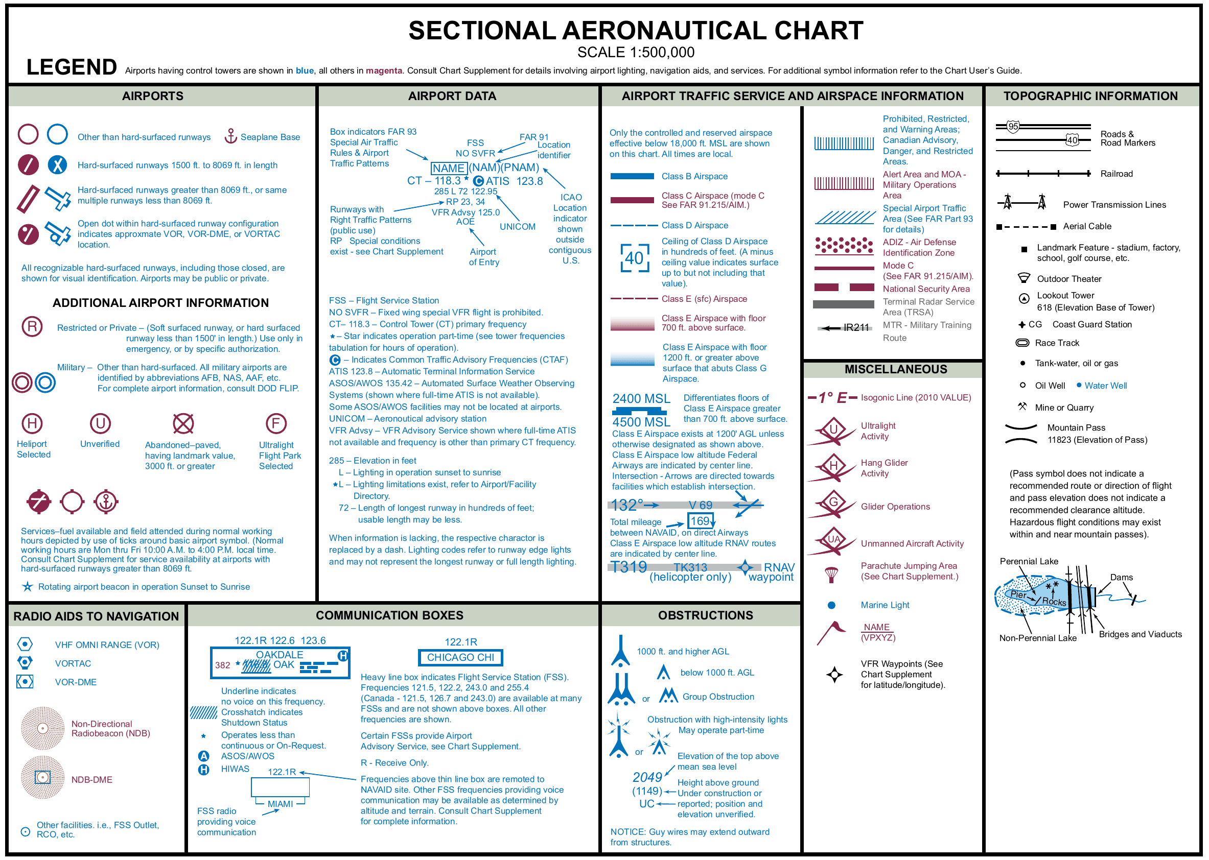
Source: AIM 3-5-2 (where the Chart User's Guide and VFR sectional charts are published); AIM 5-1-1 (sectional charts updated every 56 days)
What changed on October 26, 2026
Since October 26, 2026, the FAA Part 107 knowledge test can include image-based questions that are not in the printed testing supplement, such as up-to-date sectional chart excerpts. The supplement is still provided at the test center, and the FAA has not set a date for removing it. The question count, time limit, passing score and content weights did not change. What ended is the promise that every figure on your test is in the booklet, so learning figure numbers and their usual answers no longer works: learn to read any sectional chart instead. The full, sourced account is in what changed on the Part 107 test.
Free tools
- Sectional chart notation decoder: type a notation you see on a chart (70/20, [29], 1549 (299)) and get its meaning with the chart guide page that defines it, then drill on fresh ones.
- Altitude drill: MSL, AGL and the 400-foot rule: convert between MSL and AGL, find the highest you may fly near a structure, and decide whether an altitude needs ATC authorization.
- Part 107 practice questions: sample questions from every part of the test, not just charts, with answers and sources.
How to use the practice pages
- Each page opens with the short answer, then the chart legend rule with its FAA source.
- Worked examples step through specific red numbered areas on real FAA sectional chart excerpts, edition effective October 29, 2026. Tap any excerpt to zoom.
- Then check yourself: 39 questions in all, three options each like the test, with the answer and the reason behind a tap.
Practice topics
- How to read Class B and Class C sector blocks How to read Class B and C sector blocks on a sectional chart: ceiling over floor in hundreds of feet MSL, SFC and T. Worked examples and Part 107 self-checks.
- Class D on a sectional chart: ceiling boxes and part-time towers Class D on a sectional chart: the dashed blue boundary, the boxed ceiling in hundreds of feet MSL, the minus sign and the part-time tower star. Self-checks.
- Class E and Class G on a sectional: magenta vs blue shading and dashed magenta Class E and G on a sectional chart: the magenta vignette (700 ft AGL), the blue vignette, the dashed magenta surface area and Class G below. Self-checks.
- Obstruction heights on a sectional chart: MSL vs AGL and the 400-ft rule Obstruction heights on a sectional chart: top in feet MSL, height AGL in parentheses, the ground elevation, and the Part 107 400-ft structure exception.
- Maximum elevation figures (MEF) on a sectional chart Maximum elevation figures (MEF) on a sectional chart: the highest terrain or obstacle in the quadrangle, rounded up, in feet MSL. Not a drone altitude limit.
- Special use airspace and military training routes on a sectional chart Special use airspace on a sectional chart: prohibited, restricted, warning and alert areas, MOAs and military training routes, with Part 107 self-checks.
- How to read an airport data block on a sectional chart How to read an airport data block on a sectional chart: blue vs magenta, CT and the part-time star, CTAF, elevation, lighting, runway length and RP.
- Do I need ATC authorization here? Reading the chart for Part 107 Do you need ATC authorization for a Part 107 flight? Class B, C, D and Class E surface areas, read from a sectional chart, with examples and self-checks.
Check the whole test, not just charts
The free Muster Check covers all five test areas in the proportions the real test uses, scores each one, and shows the cited source for every question.
Chart excerpts: FAA VFR sectional charts (public domain), markers added. Rules: FAA Aeronautical Chart User's Guide, Aeronautical Information Manual, Remote Pilot Study Guide and 14 CFR part 107. Independent study tool. Not affiliated with or endorsed by the FAA.