How to read Class B and Class C sector blocks
A sector block is two numbers stacked like a fraction. The top number is the ceiling and the bottom number is the floor of that piece of airspace, both in hundreds of feet above mean sea level (MSL): add two zeros and keep it MSL. Solid blue figures are Class B, solid magenta figures are Class C, SFC means the sector starts at the surface, and a T ceiling on a Class C block means up to, but not including, the floor of the Class B above it.
Last reviewed
The excerpts are cut from FAA sectional charts, edition effective October 29, 2026, with red numbered markers (areas) added by us. Sectional charts are updated every 56 days, so every reading below describes the excerpt as printed, not the chart you would buy today.
The legend rule
The Chart User's Guide says the MSL ceiling and floor of each Class B sector are shown in solid blue figures with the last two zeros omitted, and those of each Class C sector in solid magenta figures, also with the last two zeros left off. So 100/30 reads as a ceiling of 10,000 ft MSL over a floor of 3,000 ft MSL.
Source: Chart User's Guide, VFR terms p. 16 (right traffic; Class B and Class C altitudes)
SFC as the bottom number means the sector reaches the ground. A Class C ceiling printed as T runs to, but not including, the floor of the overlying Class B. A floor preceded by a plus sign means "upward from above" that altitude: at and below it you are outside the Class B.
Source: Chart User's Guide, VFR terms p. 16 (right traffic; Class B and Class C altitudes)
Why the blocks change from ring to ring: Class B is generally surface to 10,000 ft MSL around the busiest airports, built from a surface area and two or more layers like an upside-down wedding cake. Class C is generally surface to 4,000 ft above the airport elevation (charted in MSL), usually a 5 NM core from the surface and a 10 NM shelf starting at 1,200 ft above the airport.
Source: Remote Pilot Study Guide ch. 2 (Class B airspace); AIM 3-2-3 (Class B airspace); Remote Pilot Study Guide ch. 2 (Class C airspace); AIM 3-2-4 (Class C airspace)
For a drone, the sector you are actually inside is what matters: no one may operate a small unmanned aircraft in Class B or Class C airspace without prior authorization from ATC. Under a shelf whose floor is well above you, you are not in that sector, though you still have to check what lies underneath it.
Source: 14 CFR 107.41 (operation in certain airspace)
Worked examples
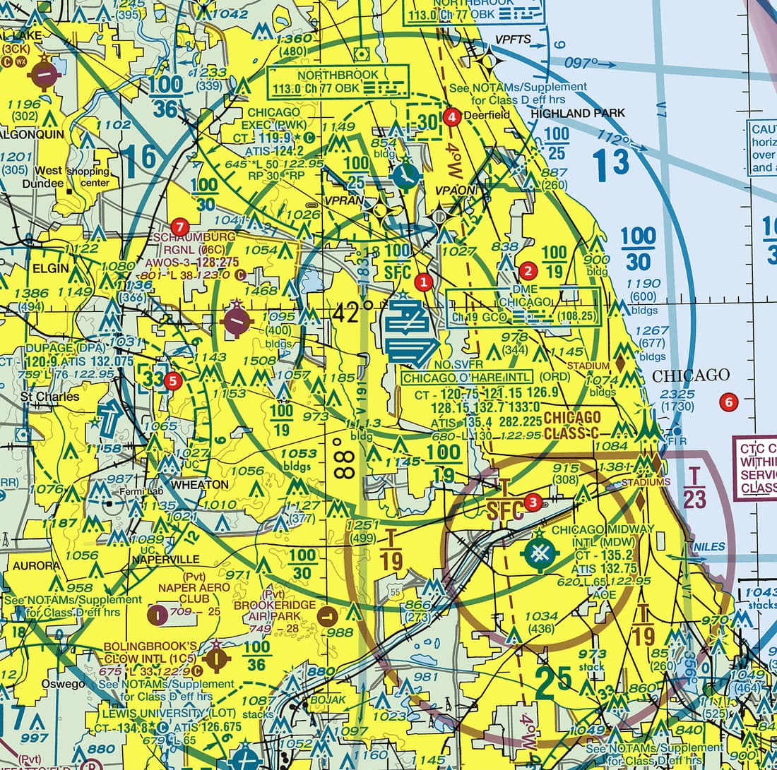
Example 1: Figure 104, area 2
What does the blue block beside area 2 mean, and is a drone at 400 ft AGL there inside it?
 Open Figure 104, area 2 full size
- The block beside area 2 reads 100 over 19 in solid blue, so it is a Class B sector.
- Add two zeros: the ceiling is 10,000 ft MSL and the floor is 1,900 ft MSL.
- Estimate the ground. The obstruction just below the block reads 978 (344): its top is 978 ft MSL and it stands 344 ft tall, so the ground there is about 978 - 344 = 634 ft MSL.
- The floor is therefore about 1,900 - 634 = 1,266 ft above the ground. A drone at 400 ft AGL (about 1,034 ft MSL) is below this sector's floor.
Reading: Class B from 1,900 ft MSL to 10,000 ft MSL. A drone at 400 ft AGL is below this sector's floor; what lies beneath it is a separate reading.
Source: Chart User's Guide, VFR terms p. 16 (right traffic; Class B and Class C altitudes); Chart User's Guide, VFR terms p. 11 (obstruction symbols: MSL top, AGL height in parentheses)
Example 2: Figure 104, area 3
What does the magenta T over SFC at area 3 mean?
Open Figure 104, area 3 full size
- Magenta figures inside the solid magenta ring around the Midway airport mean Class C.
- SFC on the bottom: this inner sector starts at the surface.
- T on top: the ceiling is not a number. The Class C runs up to, but not including, the floor of the Class B that sits over it, so the Class B blocks around it give the actual altitude.
Reading: Class C from the surface up to, but not including, the floor of the overlying Class B.
Source: Chart User's Guide, VFR terms p. 16 (right traffic; Class B and Class C altitudes)
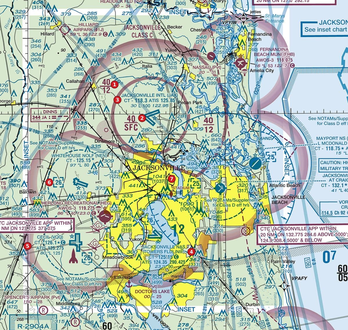
Example 3: Figure 108, areas 1 and 2
Compare the two magenta blocks at areas 1 and 2. How does this Class C fit the usual core-and-shelf shape?
 Open Figure 108, areas 1 and 2 full size
- Area 2 (over the airport) reads 40 over SFC: Class C from the surface to 4,000 ft MSL. That is the core.
- Area 1 (on the outer ring) reads 40 over 12: Class C from 1,200 ft MSL to 4,000 ft MSL. That is the shelf.
- The airport's data block at area 3 gives a field elevation of 30 ft, so the ceiling is about 3,970 ft above the field and the shelf floor about 1,170 ft above it, close to the usual 4,000 ft and 1,200 ft above the airport.
Reading: Core: surface to 4,000 ft MSL. Shelf: 1,200 ft MSL to 4,000 ft MSL. Both are MSL figures, read from the blocks, not assumed.
Source: Chart User's Guide, VFR terms p. 16 (right traffic; Class B and Class C altitudes); Remote Pilot Study Guide ch. 2 (Class C airspace); Chart User's Guide, VFR terms p. 15 (airport data: elevation, runway length, CT, star, CTAF)
Check yourself
Three options each, as on the test. Pick one, then open the answer.
-
 Open Figure 101, area 1 full size
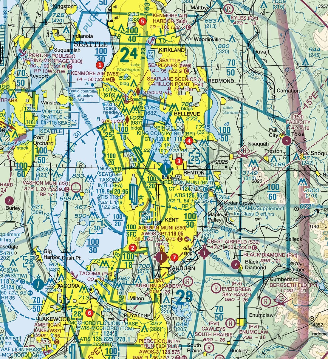
Figure 101, area 1 Coastal metropolitan area with Class B sector blocks, satellite Class D airports and a seaplane base. Tap to zoom. What airspace does the blue sector block next to area 1 describe?
Show the answer
A. Class B from 3,000 ft MSL to 10,000 ft MSL. The block reads 100 over 30: ceiling and floor in hundreds of feet MSL, so 10,000 ft MSL over 3,000 ft MSL.
Source: Chart User's Guide, VFR terms p. 16 (right traffic; Class B and Class C altitudes)
-
 Open Figure 102, area 2 full size
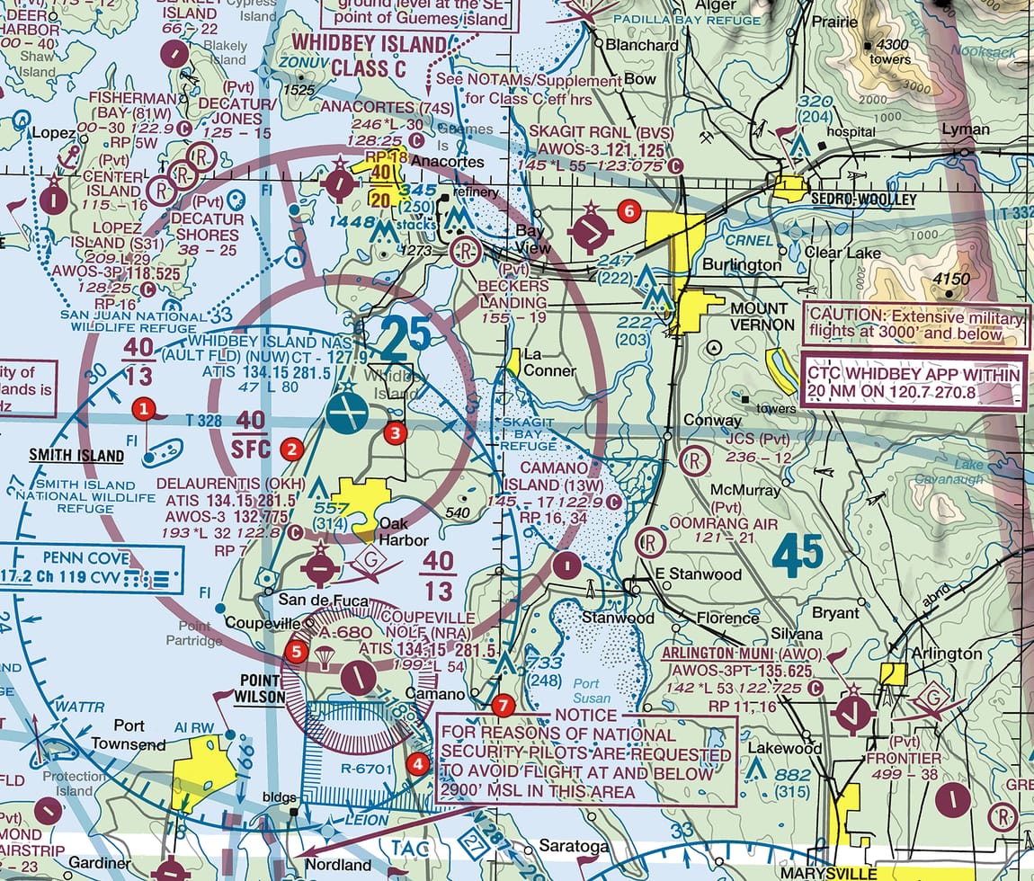
Figure 102, area 2 Island Class C with sector blocks, a restricted area, an alert area and a national-security notice. Tap to zoom. What does the magenta 40 over SFC beside area 2 mean?
Show the answer
C. Class C from the surface to 4,000 ft MSL. Solid magenta altitude figures are Class C, in hundreds of feet MSL; SFC is the surface.
Source: Chart User's Guide, VFR terms p. 16 (right traffic; Class B and Class C altitudes)
-
Open Figure 104, area 3 full size
Figure 104, area 3 Lakeside metropolitan Class B with two major airports, sector blocks, a Class C core and satellite Class D airports. Tap to zoom. What is the ceiling of the Class C sector marked T over SFC at area 3?
Show the answer
A. Up to, but not including, the floor of the overlying Class B. On a Class C block, a T ceiling means the Class C extends to, but not including, the floor of the Class B above it.
Source: Chart User's Guide, VFR terms p. 16 (right traffic; Class B and Class C altitudes)
-
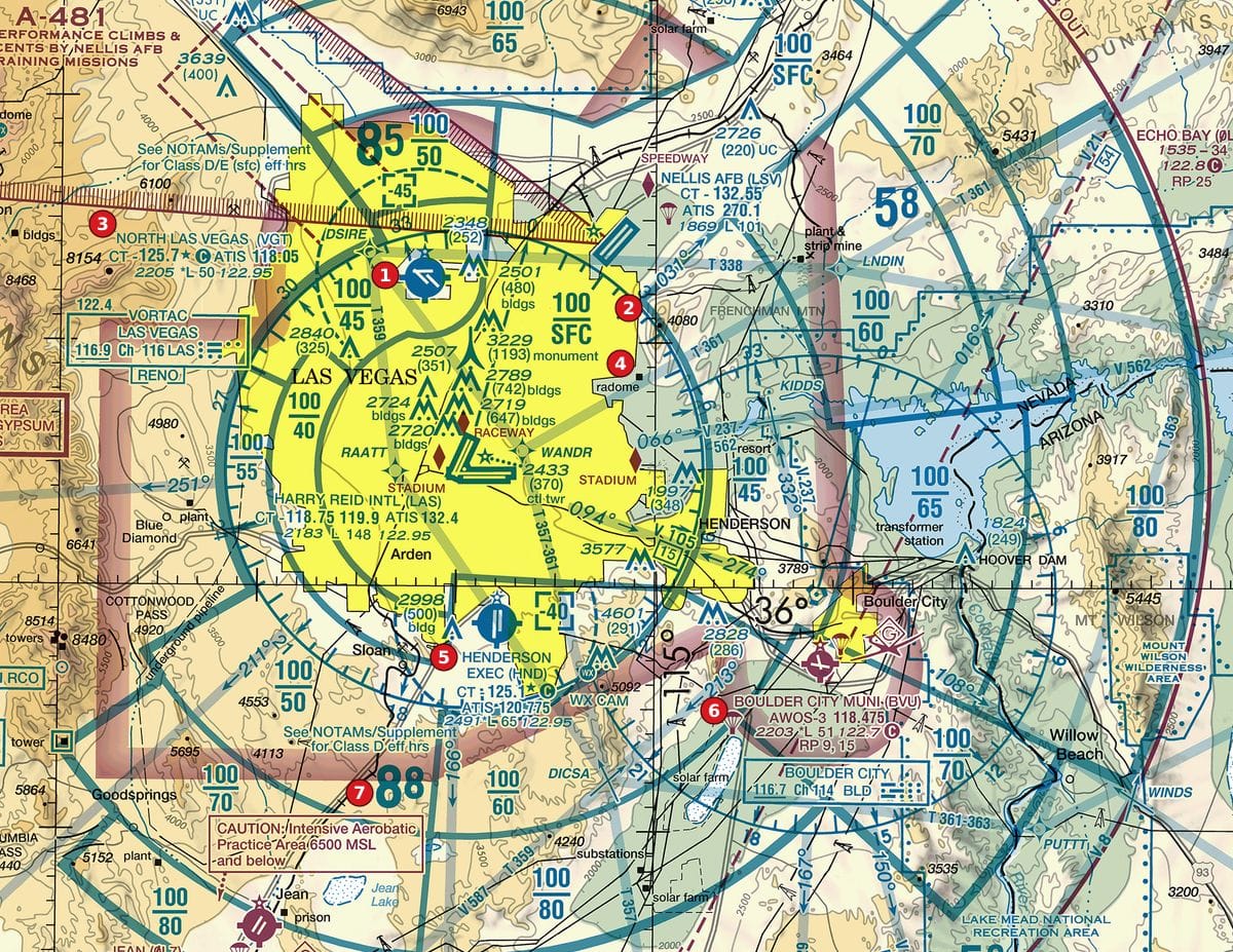 Open Figure 106, areas 1 and 3 full size
Figure 106, areas 1 and 3 Desert metropolitan area with Class B sector blocks, satellite Class D airports and obstructions. Tap to zoom. The block beside area 1 (100 over 45) covers the North Las Vegas airport, whose data block at area 3 gives a field elevation of 2,205 ft. About how far above the field does that Class B sector begin?
Show the answer
B. About 2,300 ft. The floor is 4,500 ft MSL. Subtract the 2,205 ft field elevation: about 2,300 ft above the airport.
Source: Chart User's Guide, VFR terms p. 16 (right traffic; Class B and Class C altitudes); Chart User's Guide, VFR terms p. 15 (airport data: elevation, runway length, CT, star, CTAF)
-
Open Figure 106, area 2 full size
Figure 106, area 2 Desert metropolitan area with Class B sector blocks, satellite Class D airports and obstructions. Tap to zoom. Area 2 sits on the eastern boundary of the sector whose block, just west of the marker, reads 100 over SFC. A remote pilot wants to fly at 100 ft AGL inside that sector. What applies?
Show the answer
B. Prior ATC authorization: it is Class B from the surface to 10,000 ft MSL. 100 over SFC is Class B from the surface to 10,000 ft MSL, and § 107.41 requires prior ATC authorization to operate in Class B.
Source: Chart User's Guide, VFR terms p. 16 (right traffic; Class B and Class C altitudes); 14 CFR 107.41 (operation in certain airspace)
Common slips
- Reading the numbers as AGL. Sector altitudes are MSL; subtract the ground elevation (from a nearby airport or an obstruction's MSL and AGL pair) to get height above ground.
- Dropping a zero, or adding one too many: 30 is 3,000 ft, not 300 ft or 30,000 ft.
- Swapping ceiling and floor. The top number is always the ceiling.
- Treating T as a number or as the tower. It means "to the Class B floor above"; read the Class B block for the altitude.
- Assuming the whole area inside the outer ring is off limits from the ground up. Only the sector you are actually inside, from its floor to its ceiling, counts.
See where you stand on the whole test
Chart reading is one part of the Part 107 test. The free Muster Check covers all five test areas in the proportions the real test uses and shows the cited source for every answer.
More chart practice
- Class D on a sectional chart: ceiling boxes and part-time towers
- Class E and Class G on a sectional: magenta vs blue shading and dashed magenta
- Obstruction heights on a sectional chart: MSL vs AGL and the 400-ft rule
- Maximum elevation figures (MEF) on a sectional chart
- Special use airspace and military training routes on a sectional chart
- How to read an airport data block on a sectional chart
- Do I need ATC authorization here? Reading the chart for Part 107
Chart excerpts: FAA VFR sectional charts (public domain), markers added. Rules: FAA Aeronautical Chart User's Guide, Aeronautical Information Manual, Remote Pilot Study Guide and 14 CFR part 107. Independent study tool. Not affiliated with or endorsed by the FAA.