Special use airspace and military training routes on a sectional chart
Special use airspace is labeled by type: P for prohibited, R for restricted, W for warning and A for alert areas, each followed by a number; MOAs are named, not numbered. Prohibited means no flight; restricted means flight is subject to restrictions and unauthorized entry can be extremely hazardous; warning and alert areas warn of hazardous or unusual activity. Military training routes are labeled IR or VR: four digits means no segment above 1,500 ft AGL, three or fewer means at least one segment above it.
Last reviewed
The excerpts are cut from FAA sectional charts, edition effective October 29, 2026, with red numbered markers (areas) added by us. Sectional charts are updated every 56 days, so every reading below describes the excerpt as printed, not the chart you would buy today.
The legend rule
Special use airspace confines certain activities and restricts entry, or cautions other aircraft, within set boundaries. On VFR charts every type except controlled firing areas is drawn, identified by type and name or number, inside or right beside the area.
Source: Remote Pilot Study Guide ch. 2 (special use airspace); Chart User's Guide, VFR terms p. 17 (special use airspace on VFR charts)
Prohibited areas (P-) are airspace in which flight is prohibited, for security or national welfare. Restricted areas (R-) are not wholly prohibited but subject to restrictions, with often invisible hazards such as artillery firing, aerial gunnery or guided missiles; entering without authorization from the using or controlling agency may be extremely hazardous.
Source: Remote Pilot Study Guide ch. 2 (prohibited areas); AIM 3-4-2 (prohibited areas); Remote Pilot Study Guide ch. 2 (restricted areas); AIM 3-4-3 (restricted areas)
Warning areas (W-) start 3 NM off the coast and contain activity that may be hazardous to nonparticipating aircraft; the U.S. does not have sole jurisdiction there. Alert areas (A-) may contain a high volume of pilot training or an unusual type of aerial activity; everyone there shares responsibility for collision avoidance. MOAs separate military training from IFR traffic and carry names, with times and altitudes on the chart.
Source: Remote Pilot Study Guide ch. 2 (warning areas); AIM 3-4-4 (warning areas); Remote Pilot Study Guide ch. 2 (alert areas); AIM 3-4-6 (alert areas); Remote Pilot Study Guide ch. 2 (military operations areas); AIM 3-4-5 (military operations areas)
Military training routes are flown by military aircraft at speeds over 250 knots, usually below 10,000 ft MSL. IR routes are flown under IFR, VR routes under VFR. Four-digit routes have no segment above 1,500 ft AGL; routes with three or fewer digits include one or more segments above 1,500 ft AGL.
Source: Remote Pilot Study Guide ch. 2 (military training routes); Chart User's Guide, VFR terms p. 18 (military training routes)
National security areas ask pilots to voluntarily avoid flying through them; flight there can be temporarily prohibited by NOTAM.
Source: Remote Pilot Study Guide ch. 2 (national security areas); Chart User's Guide, VFR terms p. 18 (national security areas)
Worked examples
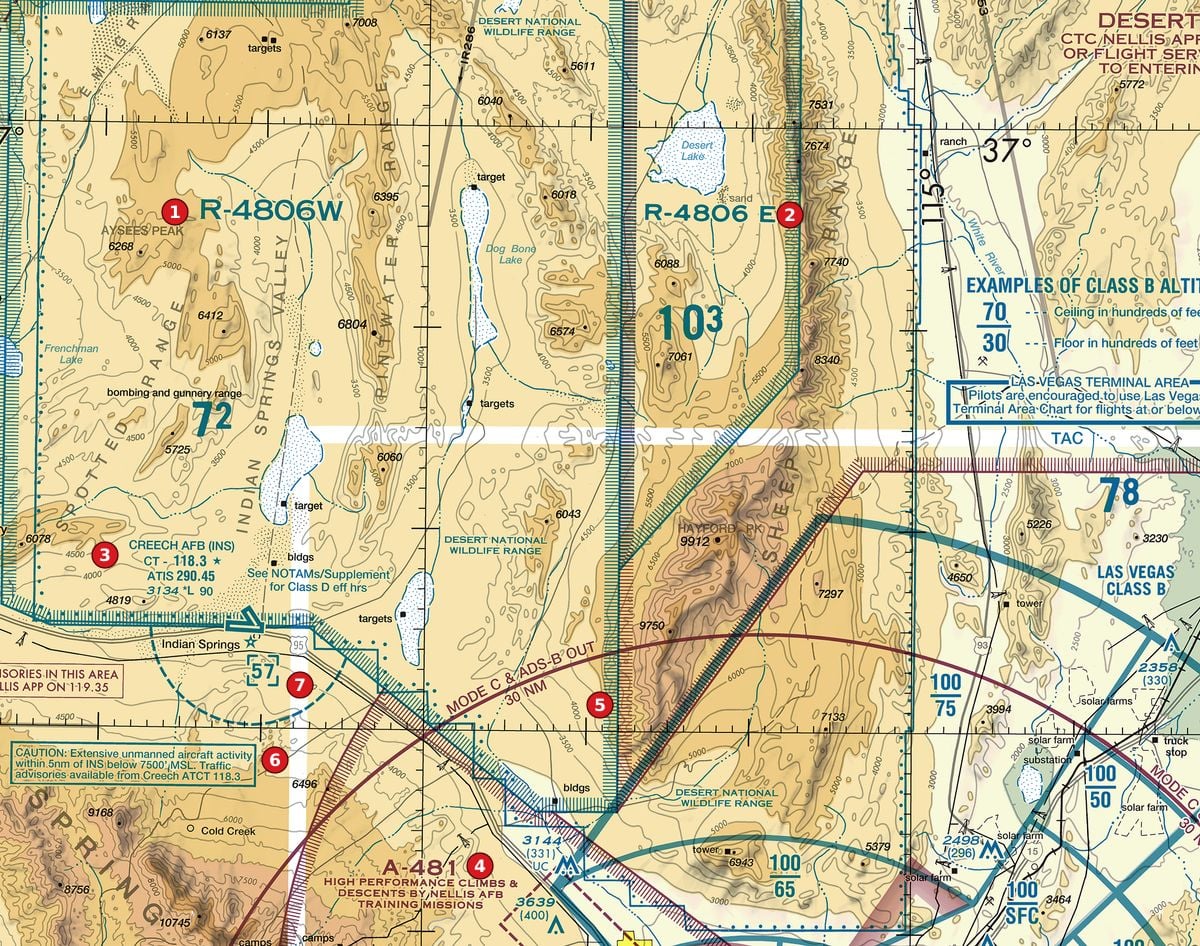
Example 1: Figure 107, areas 1 and 2
What are the two large blocks labelled at areas 1 and 2?
 Open Figure 107, areas 1 and 2 full size
- Area 1 reads R-4806W and area 2 reads R-4806 E: the R prefix means restricted areas.
- On this excerpt the words bombing and gunnery range and target appear inside them, the kind of invisible hazard restricted areas exist for.
- Flight inside is not wholly prohibited, but entry without authorization from the using or controlling agency may be extremely hazardous; the area's times and altitudes are in the chart's special use airspace information.
Reading: Two restricted areas. Do not enter without authorization from the controlling agency.
Source: Remote Pilot Study Guide ch. 2 (restricted areas); AIM 3-4-3 (restricted areas); Chart User's Guide, VFR terms p. 17 (special use airspace on VFR charts)
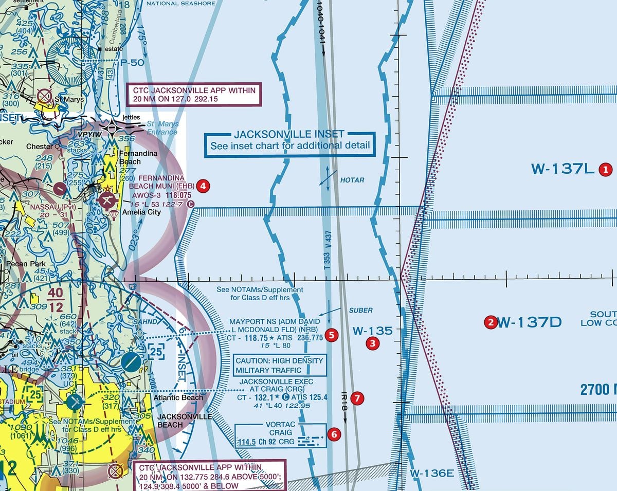
Example 2: Figure 109, areas 1, 2 and 3
What are the blocks offshore at areas 1 to 3, and the small P-50 circle at the top left?
 Open Figure 109, areas 1, 2 and 3 full size
- Areas 1, 2 and 3 are W-137L, W-137D and W-135: warning areas, off the coast, with activity that may be hazardous to nonparticipating aircraft.
- The small circle labelled P-50 near the river mouth at the top left is a prohibited area: flight there is prohibited.
Reading: Three warning areas offshore and one prohibited area by the coast.
Source: Remote Pilot Study Guide ch. 2 (warning areas); AIM 3-4-4 (warning areas); Remote Pilot Study Guide ch. 2 (prohibited areas); AIM 3-4-2 (prohibited areas)
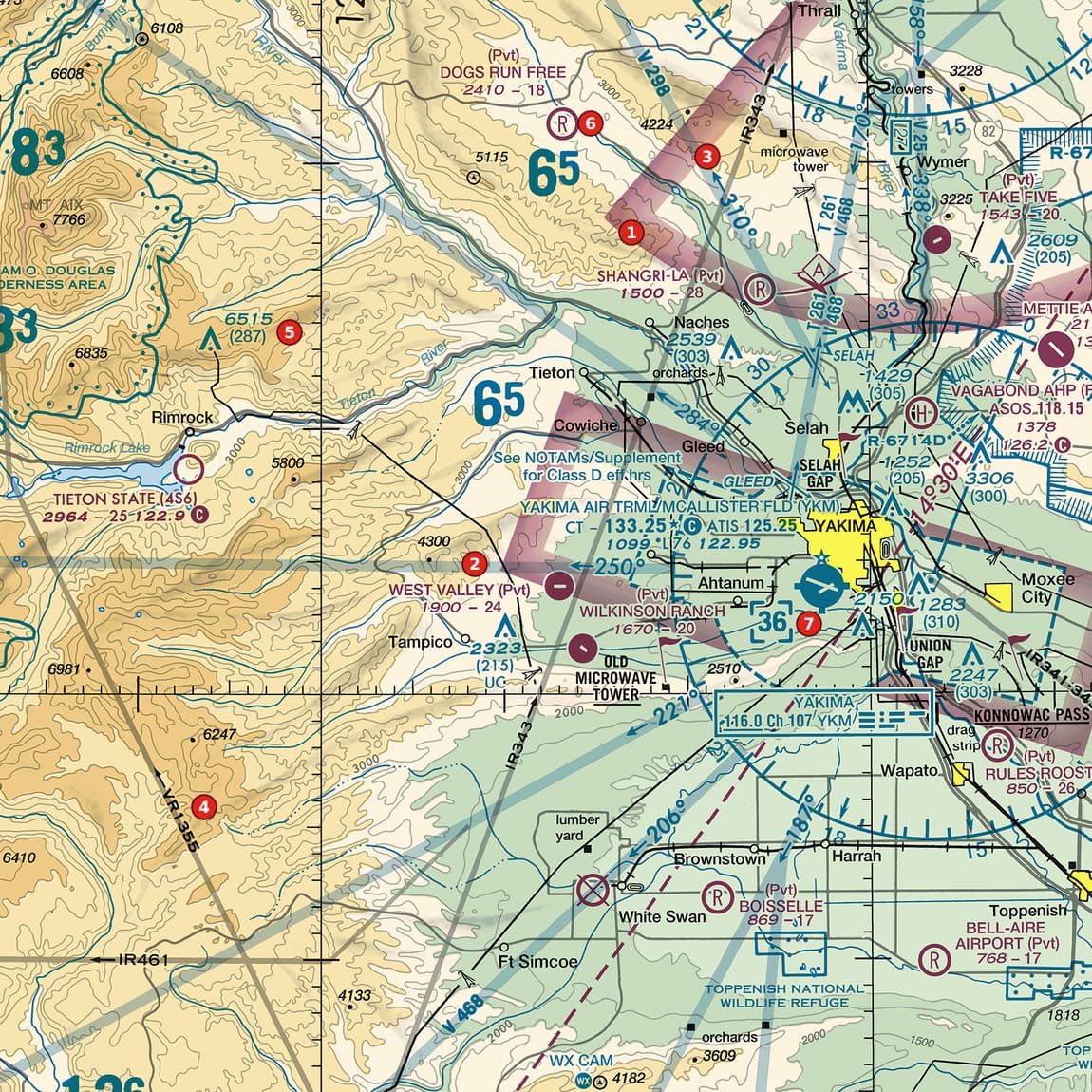
Example 3: Figure 103, areas 3 and 4
Compare the military training routes at areas 3 (IR343) and 4 (VR1355).
 Open Figure 103, areas 3 and 4 full size
- IR343: an IFR route with a three-digit number, so it includes one or more segments above 1,500 ft AGL.
- VR1355: a VFR route with a four-digit number, so none of its segments is above 1,500 ft AGL: the whole route is low.
- Either way, expect fast military aircraft (over 250 knots) along the line; a drone pilot flying near one should keep a sharp lookout.
Reading: IR343 has at least one segment above 1,500 ft AGL; VR1355 stays at or below 1,500 ft AGL throughout.
Source: Remote Pilot Study Guide ch. 2 (military training routes); Chart User's Guide, VFR terms p. 18 (military training routes)
Check yourself
Three options each, as on the test. Pick one, then open the answer.
-
 Open Figure 102, area 5 full size
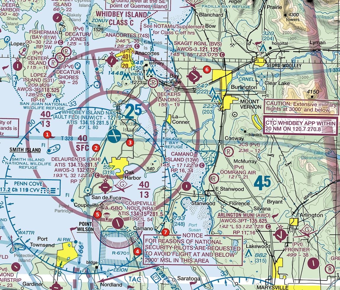
Figure 102, area 5 Island Class C with sector blocks, a restricted area, an alert area and a national-security notice. Tap to zoom. What kind of airspace is A-680 at area 5?
Show the answer
B. An alert area: high-volume pilot training or unusual aerial activity. An A followed by a number is an alert area. Pilots should exercise caution there.
Source: Remote Pilot Study Guide ch. 2 (alert areas); AIM 3-4-6 (alert areas)
-
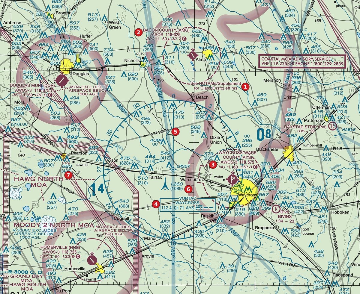 Open Figure 110, area 7 full size
Figure 110, area 7 Rural pine country with Class E surface areas at non-towered airports, a VORTAC, military training routes and towers. Tap to zoom. What is the HAWG NORTH area labelled at area 7?
Show the answer
A. A military operations area. MOAs are named rather than numbered and exist to separate military training from IFR traffic.
Source: Remote Pilot Study Guide ch. 2 (military operations areas)
-
Open Figure 110, area 5 full size
Figure 110, area 5 Rural pine country with Class E surface areas at non-towered airports, a VORTAC, military training routes and towers. Tap to zoom. What does the route number VR1001 at area 5 tell you?
Show the answer
C. It has no segment above 1,500 ft AGL. Four-digit military training routes have no segment above 1,500 ft AGL; VR routes are flown under VFR.
Source: Remote Pilot Study Guide ch. 2 (military training routes); Chart User's Guide, VFR terms p. 18 (military training routes)
-
Open Figure 109, area 7 full size
Figure 109, area 7 Atlantic coastline with offshore warning areas, a prohibited area and coastal airports. Tap to zoom. What is IR18 at area 7?
Show the answer
A. An IFR military training route with at least one segment above 1,500 ft AGL. IR means flown under IFR; a number of three or fewer digits means one or more segments above 1,500 ft AGL.
Source: Remote Pilot Study Guide ch. 2 (military training routes); Chart User's Guide, VFR terms p. 18 (military training routes)
-
Open Figure 102, area 4 full size
Figure 102, area 4 Island Class C with sector blocks, a restricted area, an alert area and a national-security notice. Tap to zoom. Area 4 sits between the restricted area R-6701 (to its left) and a magenta box to its right: NOTICE: FOR REASONS OF NATIONAL SECURITY PILOTS ARE REQUESTED TO AVOID FLIGHT AT AND BELOW 2900' MSL IN THIS AREA. What does it ask?
Show the answer
B. Pilots are asked to voluntarily avoid flight at and below 2,900 ft MSL there. The notice is a request: pilots are asked to voluntarily avoid such areas, though flight can be temporarily prohibited by NOTAM.
Source: Remote Pilot Study Guide ch. 2 (national security areas); Chart User's Guide, VFR terms p. 18 (national security areas)
Common slips
- Treating restricted like prohibited, or like nothing. Restricted is not wholly prohibited, but entering without authorization can be extremely hazardous.
- Reading MTR digits backwards. Four digits: no segment above 1,500 ft AGL. Three or fewer: at least one above it.
- Ignoring MTRs at drone altitudes. Four-digit routes are low, and the aircraft on them are fast.
- Looking for a number on a MOA. MOAs are named; times and altitudes are in the chart's tables.
See where you stand on the whole test
Chart reading is one part of the Part 107 test. The free Muster Check covers all five test areas in the proportions the real test uses and shows the cited source for every answer.
More chart practice
- How to read Class B and Class C sector blocks
- Class D on a sectional chart: ceiling boxes and part-time towers
- Class E and Class G on a sectional: magenta vs blue shading and dashed magenta
- Obstruction heights on a sectional chart: MSL vs AGL and the 400-ft rule
- Maximum elevation figures (MEF) on a sectional chart
- How to read an airport data block on a sectional chart
- Do I need ATC authorization here? Reading the chart for Part 107
Chart excerpts: FAA VFR sectional charts (public domain), markers added. Rules: FAA Aeronautical Chart User's Guide, Aeronautical Information Manual, Remote Pilot Study Guide and 14 CFR part 107. Independent study tool. Not affiliated with or endorsed by the FAA.