Read the numbers on a sectional chart
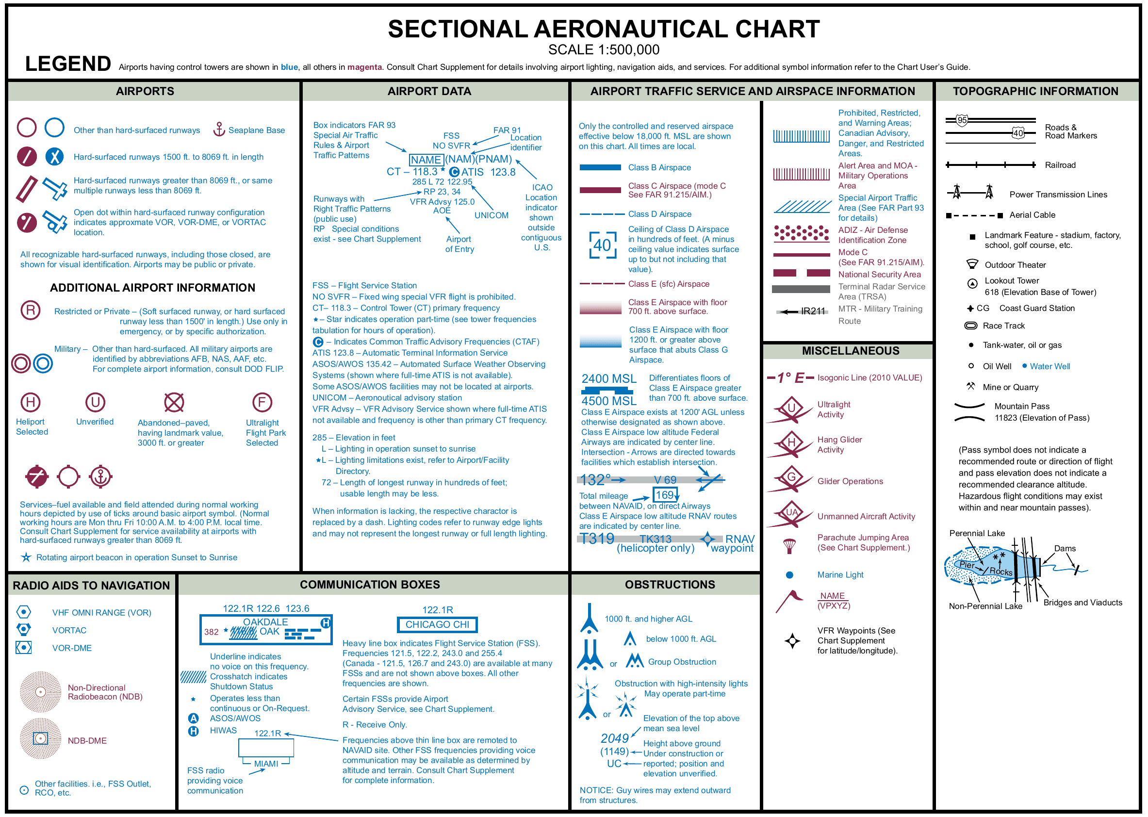
Sectional charts pack airspace limits, obstacle heights and airport data into a few digits. Type what you see on the chart (or pick an example) to get its meaning and the FAA source that defines it. Then practice until the classic slips (MSL or AGL, ceiling or floor, hundreds of feet or feet) stop catching you.
Last reviewed
Decoder
Try an example
What can I type?
Sector blocks (70/20, 40/SFC, T/12), Class D boxes ([29], [-30]), Class E floors (2400 MSL), obstructions (1549 (299), 2894 UC), maximum elevation figures (MEF 28), airport data block lines (CT - 118.3 *, 285 L 72, 122.8 C), special use areas (R-2508, P-40, W-237, A-211, ... MOA) and military training routes (IR206, VR1207). The chart's own ★ and circled C work too. Anything else is marked "not recognized" rather than guessed, and figures that cannot be right (a ceiling under its floor) are flagged.
Decoded notation
What it means · 6 notations
-
CT - 118.3 *
Control tower, part-time
Control tower (CT) primary frequency 118.3. The star means the tower operates part-time; the tower frequencies tabulation gives its hours.
Source: Chart User's Guide, VFR terms p. 15 (airport data: elevation, runway length, CT, CTAF, ATIS, ASOS/AWOS); Chart User's Guide, VFR terms p. 15 (airport lighting codes, UNICOM)
-
C
C (CTAF)
C follows the Common Traffic Advisory Frequency (CTAF): the frequency just before it is the one to monitor and self-announce on.
Source: Chart User's Guide, VFR terms p. 15 (airport data: elevation, runway length, CT, CTAF, ATIS, ASOS/AWOS)
-
ATIS 123.8
ATIS
Automatic Terminal Information Service on 123.8.
Source: Chart User's Guide, VFR terms p. 15 (airport data: elevation, runway length, CT, CTAF, ATIS, ASOS/AWOS)
-
285 L 72
Elevation, lighting, runway length
Airport elevation 285 ft (the highest point of the usable landing area). L: runway lighting in operation sunset to sunrise. Longest runway about 7,200 ft (the 72 is in hundreds of feet, rounded to the nearest 100; usable length may be less).
Lighting codes refer to runway edge lights and may not cover the longest runway or its full length.
Source: Chart User's Guide, VFR terms p. 15 (airport data: elevation, runway length, CT, CTAF, ATIS, ASOS/AWOS); Chart User's Guide, VFR terms p. 15 (airport data: elevation, runway length, CT, CTAF, ATIS, ASOS/AWOS)
-
122.95
Frequency
122.95: in the data block's last line, the UNICOM (aeronautical advisory station) frequency.
Source: Chart User's Guide, VFR terms p. 15 (airport data: elevation, runway length, CT, CTAF, ATIS, ASOS/AWOS); Chart User's Guide, VFR terms p. 15 (airport lighting codes, UNICOM)
-
RP 23, 34
Right traffic pattern
Runways 23, 34 use a right traffic pattern.
Source: Chart User's Guide, VFR terms p. 16 (right traffic, Class B and Class C altitudes)
Practice: what does this mean?
Practice notations are generated for drilling; they do not describe real places.
What to know for the test
- Airspace figures are hundreds of feet MSL. 70/20 is 7,000 ft MSL over 2,000 ft MSL, never AGL. To compare with your drone's height, subtract the ground elevation.
- Top figure ceiling, bottom figure floor. SFC means the sector starts at the surface.
- A Class D box is its ceiling. [29]: surface to 2,900 ft MSL. A minus, [-29], means up to but not including 2,900.
- Obstructions: MSL on top, AGL in parentheses. 1549 (299) is a 299 ft structure whose top is 1,549 ft above sea level.
- Runway length is in hundreds of feet: 285 L 72 means a 7,200 ft runway at an airport 285 ft high, lit sunset to sunrise.
- Stars mean part-time or limits. CT - 118.3 * is a part-time tower; *L means lighting limitations.
Then apply the rule: Class B, Class C, Class D and the surface area of Class E around an airport all need prior ATC authorization for a drone (14 CFR 107.41). The altitude drill practices the arithmetic.
Notation reference
Each notation the decoder knows, grouped the way the chart groups them.
Class B and C airspace
-
70/20
Sector altitudes (ceiling over floor)
Ceiling 7,000 ft MSL. Floor 2,000 ft MSL. Figures are in hundreds of feet MSL, last two zeros left off.
Solid blue figures are Class B, solid magenta Class C, solid black a TRSA sector.
Source: Chart User's Guide, VFR terms p. 16 (right traffic, Class B and Class C altitudes); Chart User's Guide, VFR terms p. 18 (TRSAs, military training routes)
-
100/SFC
Sector altitudes (ceiling over floor)
Ceiling 10,000 ft MSL. Floor: the surface. Figures are in hundreds of feet MSL, last two zeros left off.
Source: Chart User's Guide, VFR terms p. 16 (right traffic, Class B and Class C altitudes); Chart User's Guide, VFR terms p. 18 (TRSAs, military training routes)
-
40/SFC
Sector altitudes (ceiling over floor)
Ceiling 4,000 ft MSL. Floor: the surface. Figures are in hundreds of feet MSL, last two zeros left off.
Source: Chart User's Guide, VFR terms p. 16 (right traffic, Class B and Class C altitudes); Chart User's Guide, VFR terms p. 18 (TRSAs, military training routes)
-
T/12
Sector altitudes (ceiling over floor)
Ceiling T: up to, but not including, the floor of the Class B airspace above it (a Class C sector). Floor 1,200 ft MSL. Figures are in hundreds of feet MSL, last two zeros left off.
Source: Chart User's Guide, VFR terms p. 16 (right traffic, Class B and Class C altitudes); Chart User's Guide, VFR terms p. 18 (TRSAs, military training routes)
-
100/+40
Sector altitudes (ceiling over floor)
Ceiling 10,000 ft MSL. Floor: upward from above 4,000 ft MSL; at and below 4,000 ft you are outside it. Figures are in hundreds of feet MSL, last two zeros left off.
Source: Chart User's Guide, VFR terms p. 16 (right traffic, Class B and Class C altitudes); Chart User's Guide, VFR terms p. 18 (TRSAs, military training routes)
Class D airspace
-
[29]
Class D ceiling box
Class D from the surface up to 2,900 ft MSL. The boxed figure is the ceiling in hundreds of feet MSL.
Class D is outlined with a dashed blue line; its ceiling is generally about 2,500 ft above the airport elevation.
Source: Chart User's Guide, VFR terms p. 16 (Class D ceilings); Chart User's Guide, sectional legend p. 27 (Class D and Class E airspace)
-
[-30]
Class D ceiling (minus)
Class D from the surface up to, but not including, 3,000 ft MSL. The minus means "from surface to but not including".
Source: Chart User's Guide, VFR terms p. 16 (Class D ceilings); Chart User's Guide, sectional legend p. 27 (Class D and Class E airspace)
Class E airspace
-
2400 MSL
Class E floor
Class E airspace begins at 2,400 ft MSL here. The chart labels Class E floors other than 700 ft and 1,200 ft AGL this way; below the floor the airspace is Class G.
Source: Chart User's Guide, sectional legend p. 27 (Class D and Class E airspace); Chart User's Guide, VFR terms p. 17 (Class E floors and ceilings, Mode C, NO SVFR)
-
CEILING 9500
Class E ceiling
Class E airspace ends at 9,500 ft MSL here. The guide prints a Class E ceiling below 18,000 ft MSL with the word CEILING along the airspace limits.
Source: Chart User's Guide, VFR terms p. 17 (Class E floors and ceilings, Mode C, NO SVFR); Chart User's Guide, sectional legend p. 27 (Class D and Class E airspace)
Terrain and obstacles
-
1549 (299)
Obstruction height
The top of the obstruction is 1,549 ft MSL; the structure itself is 299 ft tall (AGL, in parentheses). The ground at its base is about 1,250 ft MSL.
Source: Chart User's Guide, VFR terms p. 11 (obstruction symbols, MSL and AGL heights)
-
2894 UC
Obstruction, unverified
Top of the obstruction at 2,894 ft MSL. UC means it is under construction, or reported but its position and elevation are not verified.
With no figure in parentheses, the chart gives no AGL height.
Source: Chart User's Guide, VFR terms p. 11 (obstruction symbols, MSL and AGL heights)
-
2⁸
Maximum Elevation Figure (MEF)
2,800 ft MSL: the highest elevation in this quadrant, terrain and obstacles (towers, trees) included, rounded up to the next 100 ft. The last two digits are not printed.
A quadrant is the area between the ticked lines every 30 minutes of latitude and longitude.
Source: Chart User's Guide, VFR terms p. 12 (Maximum Elevation Figures)
-
13⁵
Maximum Elevation Figure (MEF)
13,500 ft MSL: the highest elevation in this quadrant, terrain and obstacles (towers, trees) included, rounded up to the next 100 ft. The last two digits are not printed.
Source: Chart User's Guide, VFR terms p. 12 (Maximum Elevation Figures)
Airport data block
-
CT - 118.3 *
Control tower, part-time
Control tower (CT) primary frequency 118.3. The star means the tower operates part-time; the tower frequencies tabulation gives its hours.
Source: Chart User's Guide, VFR terms p. 15 (airport data: elevation, runway length, CT, CTAF, ATIS, ASOS/AWOS); Chart User's Guide, VFR terms p. 15 (airport lighting codes, UNICOM)
-
ATIS 123.8
ATIS
Automatic Terminal Information Service on 123.8.
Source: Chart User's Guide, VFR terms p. 15 (airport data: elevation, runway length, CT, CTAF, ATIS, ASOS/AWOS)
-
ASOS 135.42
ASOS / AWOS
Automated surface weather observing system (ASOS) on 135.42. Shown when full-time ATIS is not available.
Source: Chart User's Guide, VFR terms p. 15 (airport data: elevation, runway length, CT, CTAF, ATIS, ASOS/AWOS)
-
285 L 72
Elevation, lighting, runway length
Airport elevation 285 ft (the highest point of the usable landing area). L: runway lighting in operation sunset to sunrise. Longest runway about 7,200 ft (the 72 is in hundreds of feet, rounded to the nearest 100; usable length may be less).
Lighting codes refer to runway edge lights and may not cover the longest runway or its full length.
Source: Chart User's Guide, VFR terms p. 15 (airport data: elevation, runway length, CT, CTAF, ATIS, ASOS/AWOS); Chart User's Guide, VFR terms p. 15 (airport data: elevation, runway length, CT, CTAF, ATIS, ASOS/AWOS)
-
1744 *L 69
Elevation, lighting, runway length
Airport elevation 1,744 ft (the highest point of the usable landing area). *L: lighting limitations exist (for example part-time, on request or pilot-controlled); check the Chart Supplement. Longest runway about 6,900 ft (the 69 is in hundreds of feet, rounded to the nearest 100; usable length may be less).
Source: Chart User's Guide, VFR terms p. 15 (airport data: elevation, runway length, CT, CTAF, ATIS, ASOS/AWOS); Chart User's Guide, VFR terms p. 15 (airport lighting codes, UNICOM)
-
571 - 80
Elevation, lighting, runway length
Airport elevation 571 ft (the highest point of the usable landing area). -: no runway edge lights. Longest runway about 8,000 ft (the 80 is in hundreds of feet, rounded to the nearest 100; usable length may be less).
Source: Chart User's Guide, VFR terms p. 15 (airport data: elevation, runway length, CT, CTAF, ATIS, ASOS/AWOS); Chart User's Guide, VFR terms p. 15 (airport lighting codes, UNICOM)
-
122.95
Frequency
122.95: in the data block's last line, the UNICOM (aeronautical advisory station) frequency.
Source: Chart User's Guide, VFR terms p. 15 (airport data: elevation, runway length, CT, CTAF, ATIS, ASOS/AWOS); Chart User's Guide, VFR terms p. 15 (airport lighting codes, UNICOM)
-
122.8 C
Frequency marked C (CTAF)
122.8: in the data block's last line, the UNICOM (aeronautical advisory station) frequency. The C that follows marks it as the Common Traffic Advisory Frequency (CTAF).
Source: Chart User's Guide, VFR terms p. 15 (airport data: elevation, runway length, CT, CTAF, ATIS, ASOS/AWOS); Chart User's Guide, VFR terms p. 15 (airport lighting codes, UNICOM)
-
RP 23, 34
Right traffic pattern
Runways 23, 34 use a right traffic pattern.
Source: Chart User's Guide, VFR terms p. 16 (right traffic, Class B and Class C altitudes)
-
NO SVFR
NO SVFR
Printed above the airport name: fixed-wing special VFR operations are prohibited at this airport (FAR 91).
Source: Chart User's Guide, VFR terms p. 17 (Class E floors and ceilings, Mode C, NO SVFR); Chart User's Guide, VFR terms p. 15 (airport data: elevation, runway length, CT, CTAF, ATIS, ASOS/AWOS)
-
VFR ADVSY 125.0
VFR advisory service
VFR advisory service on 125.0: shown when ATIS is not available and the frequency differs from the primary tower frequency.
Source: Chart User's Guide, VFR terms p. 15 (airport data: elevation, runway length, CT, CTAF, ATIS, ASOS/AWOS)
Special use airspace
-
P-40
Prohibited area
P-40: Prohibited area: flight of aircraft is prohibited inside it.
Times of use, altitudes and the controlling agency are listed on the chart (special use airspace tabulation).
Source: Chart User's Guide, VFR terms p. 17 (special use airspace on VFR charts)
-
R-4401
Restricted area
R-4401: Restricted area: flight is not wholly prohibited but is subject to restrictions; it often holds invisible hazards such as artillery firing or guided missiles. Entering without authorization from the using or controlling agency may be extremely hazardous.
Source: Chart User's Guide, VFR terms p. 17 (special use airspace on VFR charts)
-
W-237
Warning area
W-237: Warning area: extends from 3 NM outward from the U.S. coast and contains activity that may be hazardous to nonparticipating aircraft.
Source: Chart User's Guide, VFR terms p. 17 (special use airspace on VFR charts)
-
A-211
Alert area
A-211: Alert area: may contain a high volume of pilot training or an unusual type of aerial activity. Use caution; everyone in it shares collision avoidance.
Source: Chart User's Guide, VFR terms p. 17 (special use airspace on VFR charts)
-
CAMDEN RIDGE MOA
Military operation area (MOA)
CAMDEN RIDGE MOA: airspace set up to separate military training from IFR traffic. MOAs are named, not numbered; times, altitudes and the controlling agency are on the chart.
Source: Chart User's Guide, VFR terms p. 17 (special use airspace on VFR charts)
Other airspace
-
VR1207
Military training route
VFR military training route. Four digits: no segment above 1,500 ft AGL.
Military aircraft on these routes often fly faster than 250 knots, usually below 10,000 ft MSL.
Source: Chart User's Guide, VFR terms p. 18 (TRSAs, military training routes)
-
IR206
Military training route
IFR military training route. Three or fewer digits: one or more segments above 1,500 ft AGL.
Source: Chart User's Guide, VFR terms p. 18 (TRSAs, military training routes)
-
30 NM MODE C
Mode C area
Mode C required airspace: from the surface to 10,000 ft MSL within 30 NM of the primary airport of a Class B area, drawn as a solid magenta line.
Source: Chart User's Guide, VFR terms p. 17 (Class E floors and ceilings, Mode C, NO SVFR)
Find your own gaps first
Airspace is one area of five. The free Muster Check covers all of them in the proportions the real test uses, scores each one, and shows the explanation and cited source for every question.
Sources
- FAA Aeronautical Chart User's Guide: VFR Terms and Symbols (pages 10 to 18) and the sectional chart symbology (pages 24 and 27).
- Remote Pilot (sUAS) Study Guide (FAA-G-8082-22), chapter 2: Class B, C, D and E airspace, special use airspace, military training routes and TRSAs.
- Aeronautical Information Manual 4-1-9 (traffic advisory practices at airports without operating control towers).
- 14 CFR Part 107 (eCFR): § 107.41 Operation in certain airspace.
- Sectional chart legend: Airman Knowledge Testing Supplement (FAA-CT-8080-2H), Legend 1.
Independent study tool. Not affiliated with or endorsed by the FAA. The FAA is named above as the publisher of public-domain documents, not as an endorser. This is a study aid; use current charts for flight.