Obstruction heights on a sectional chart: MSL vs AGL and the 400-ft rule
An obstruction label has two numbers. The upper one is the elevation of the top above mean sea level (MSL); the one in parentheses is the height of the structure above the ground (AGL). Subtract the AGL figure from the MSL figure to get the ground elevation. For a drone, the AGL figure is the one that matters for § 107.51(b): no higher than 400 ft AGL, except within a 400-ft radius of a structure, where you may go up to 400 ft above its top.
Last reviewed
The excerpts are cut from FAA sectional charts, edition effective October 29, 2026, with red numbered markers (areas) added by us. Sectional charts are updated every 56 days, so every reading below describes the excerpt as printed, not the chart you would buy today.
The legend rule
The chart gives the elevation of the top of the obstacle above MSL and the height of the structure AGL when known; the AGL height is in parentheses below the MSL elevation. In congested areas the AGL value may be left off, and in city complexes only the highest obstacle is shown, with the group obstacle symbol. UC marks an obstacle under construction or not yet verified.
Source: Chart User's Guide, VFR terms p. 11 (obstruction symbols: MSL top, AGL height in parentheses)
Sectionals typically show man-made obstacles more than 200 ft AGL, or more than 299 ft AGL inside the yellow city tint, so shorter structures may not be charted. Obstacles 1,000 ft AGL and higher use their own symbol.
Source: Chart User's Guide, VFR terms p. 11 (which obstacles are charted); Chart User's Guide, sectional legend p. 33 (obstruction and MEF symbols)
Guy wires can extend about 1,500 ft horizontally from a tower and are very hard to see, so skeletal structures should be avoided horizontally by at least 2,000 ft. New towers may not be on your current chart.
Source: Remote Pilot Study Guide ch. 11 (antenna towers and guy wires)
Under § 107.51(b) a small unmanned aircraft may not fly higher than 400 ft above ground level unless it is flown within a 400-ft radius of a structure and does not fly higher than 400 ft above the structure's immediate uppermost limit. Airspace is a separate check: climbing above 400 ft AGL can take you into a different airspace class.
Source: 14 CFR 107.51 (operating limitations: 400 ft AGL and the structure exception); AIM 11-4-2 (Part 107 operations in Class G and controlled airspace)
Worked examples
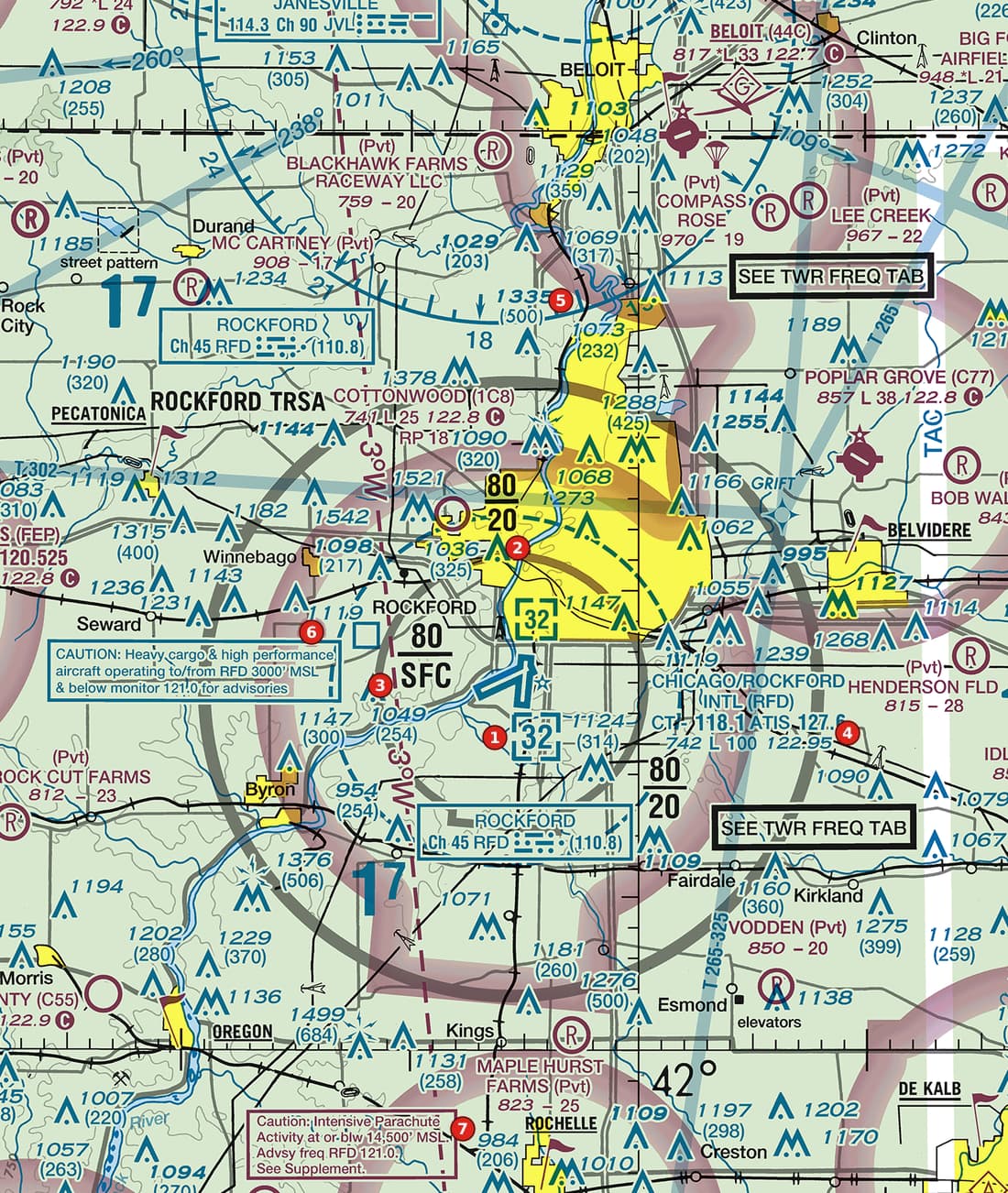
Example 1: Figure 105, area 5
Read the obstruction at area 5. How high may a drone go next to it under § 107.51(b)?
 Open Figure 105, area 5 full size
- The label reads 1335 over (500): the top is 1,335 ft MSL and the tower is 500 ft tall.
- Ground elevation: 1,335 - 500 = 835 ft MSL.
- Away from the tower, the limit is 400 ft AGL.
- Within a 400-ft radius of it, the limit is 400 ft above its top: 500 + 400 = 900 ft AGL, which is 1,735 ft MSL.
- That is the altitude rule only; the airspace above 400 ft AGL still has to be checked.
Reading: Top 1,335 ft MSL, 500 ft tall, ground 835 ft MSL. Within 400 ft of it: up to 900 ft AGL (1,735 ft MSL); elsewhere 400 ft AGL.
Source: Chart User's Guide, VFR terms p. 11 (obstruction symbols: MSL top, AGL height in parentheses); 14 CFR 107.51 (operating limitations: 400 ft AGL and the structure exception)
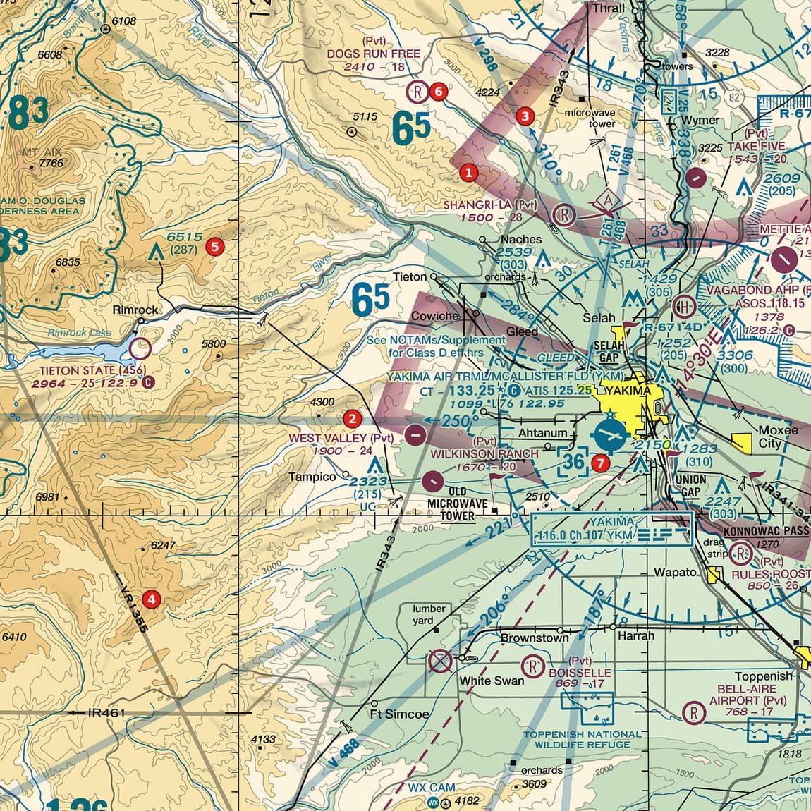
Example 2: Figure 103, area 5
The obstruction on the ridge at area 5 reads 6515 (287). Is that a 6,515-ft tower?
 Open Figure 103, area 5 full size
- No. 6,515 ft is the elevation of its top above sea level, and the ridge itself is high.
- The figure in parentheses, 287, is the structure's height above the ground.
- Ground elevation: 6,515 - 287 = 6,228 ft MSL.
Reading: A 287-ft structure whose top is 6,515 ft MSL, standing on ground at about 6,228 ft MSL.
Source: Chart User's Guide, VFR terms p. 11 (obstruction symbols: MSL top, AGL height in parentheses)
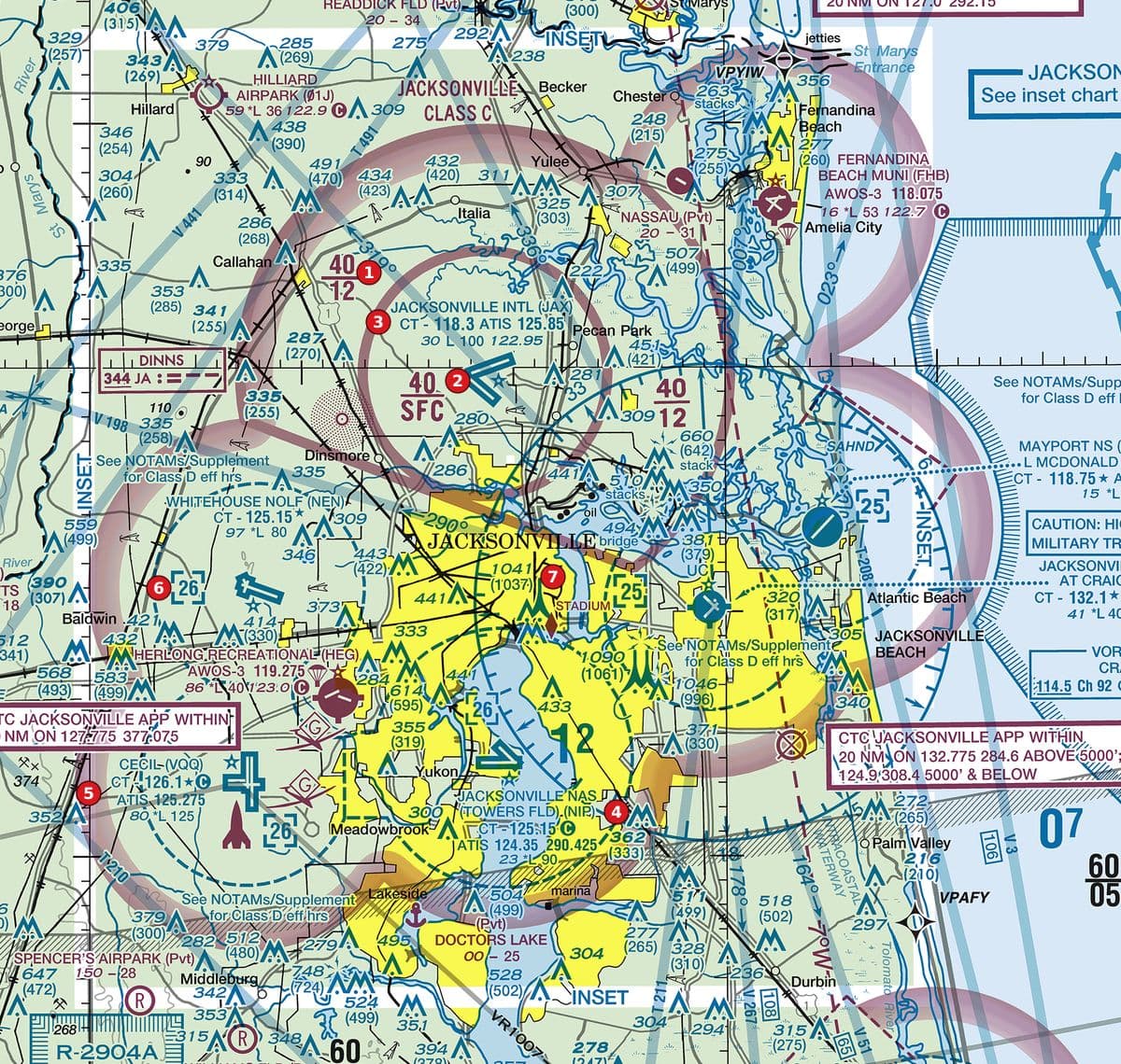
Example 3: Figure 108, area 7
The obstruction at area 7 reads 1041 (1037). What does the near-match of the two numbers tell you?
 Open Figure 108, area 7 full size
- Top: 1,041 ft MSL. Height: 1,037 ft AGL.
- Ground: 1,041 - 1,037 = 4 ft MSL, at the river's edge, so MSL and AGL are almost the same here.
- At 1,000 ft AGL or more, this structure is in the chart's tallest obstruction class, with its own symbol. Guy wires around a tower this tall can reach far out.
Reading: A 1,037-ft structure on ground about 4 ft above sea level; near the coast the two numbers nearly agree, inland they do not.
Source: Chart User's Guide, VFR terms p. 11 (obstruction symbols: MSL top, AGL height in parentheses); Chart User's Guide, sectional legend p. 33 (obstruction and MEF symbols); Remote Pilot Study Guide ch. 11 (antenna towers and guy wires)
Check yourself
Three options each, as on the test. Pick one, then open the answer.
-
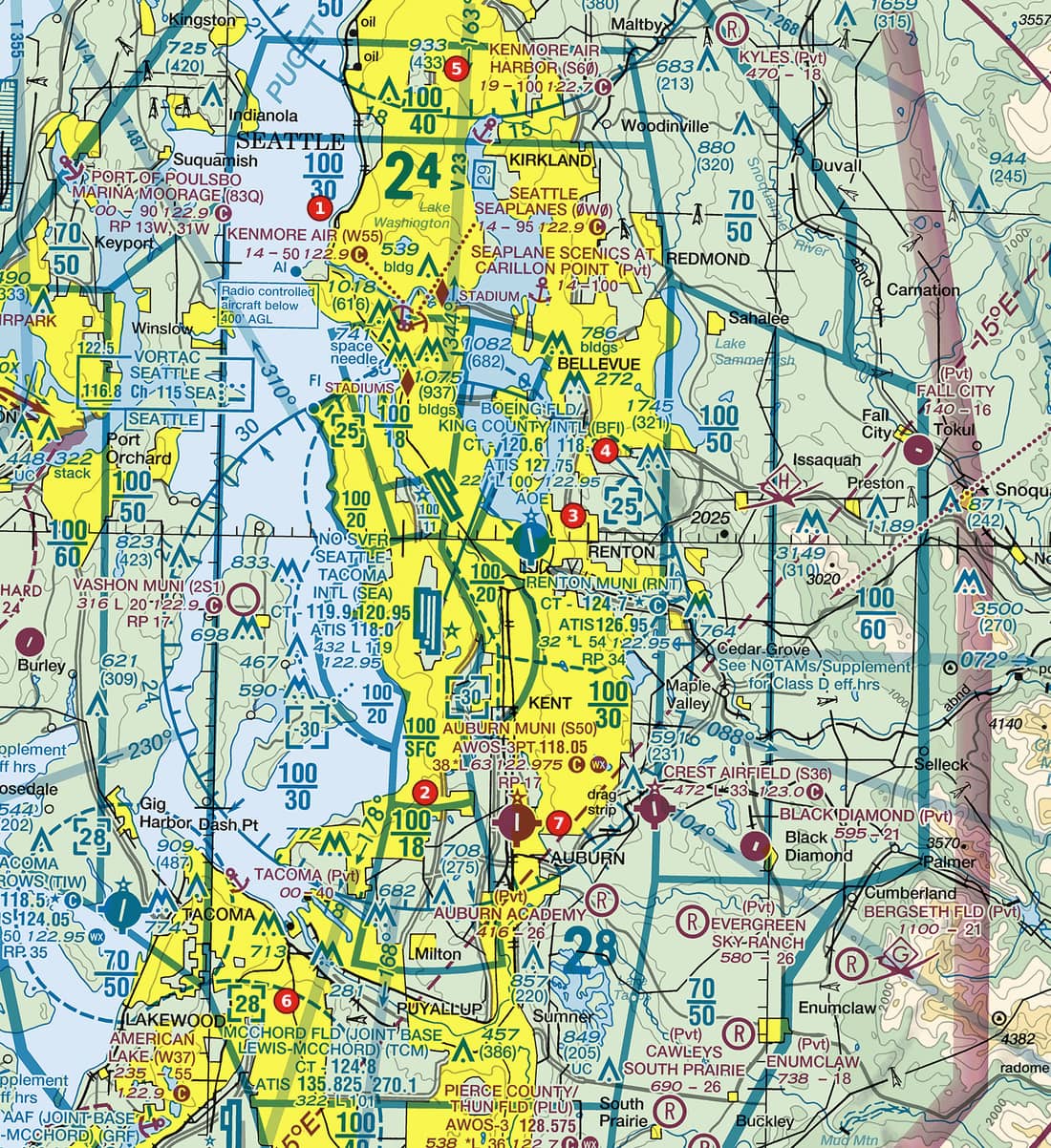 Open Figure 101, area 5 full size
Figure 101, area 5 Coastal metropolitan area with Class B sector blocks, satellite Class D airports and a seaplane base. Tap to zoom. How tall is the obstruction at area 5 above the ground?
Show the answer
C. 433 ft. The label is 933 (433): 933 ft is the top above MSL; 433 ft, in parentheses, is the height AGL.
Source: Chart User's Guide, VFR terms p. 11 (obstruction symbols: MSL top, AGL height in parentheses)
-
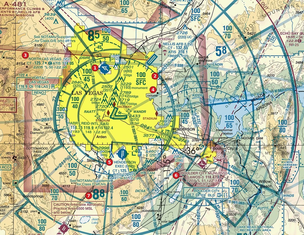 Open Figure 106, area 4 full size
Figure 106, area 4 Desert metropolitan area with Class B sector blocks, satellite Class D airports and obstructions. Tap to zoom. Just west of area 4 (left of the marker, in the city) is an obstruction labelled 3229 (1193) monument. What is the elevation of the ground at its base?
Show the answer
A. About 2,036 ft MSL. Ground elevation = top (MSL) minus height (AGL): 3,229 - 1,193 = 2,036 ft MSL.
Source: Chart User's Guide, VFR terms p. 11 (obstruction symbols: MSL top, AGL height in parentheses)
-
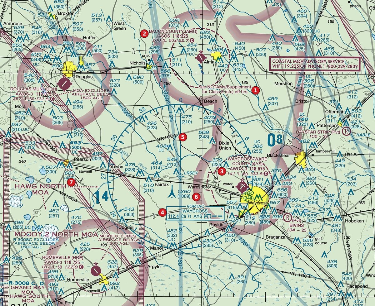 Open Figure 110, area 6 full size
Figure 110, area 6 Rural pine country with Class E surface areas at non-towered airports, a VORTAC, military training routes and towers. Tap to zoom. Considering only § 107.51(b), how high may a drone fly within a 400-ft radius of the obstruction at area 6, labelled 1260 (1089)?
Show the answer
B. 1,489 ft AGL. Within 400 ft of a structure the limit is 400 ft above its top: 1,089 + 400 = 1,489 ft AGL (1,660 ft is the MSL altitude of that point, not its height AGL).
Source: Chart User's Guide, VFR terms p. 11 (obstruction symbols: MSL top, AGL height in parentheses); 14 CFR 107.51 (operating limitations: 400 ft AGL and the structure exception)
-
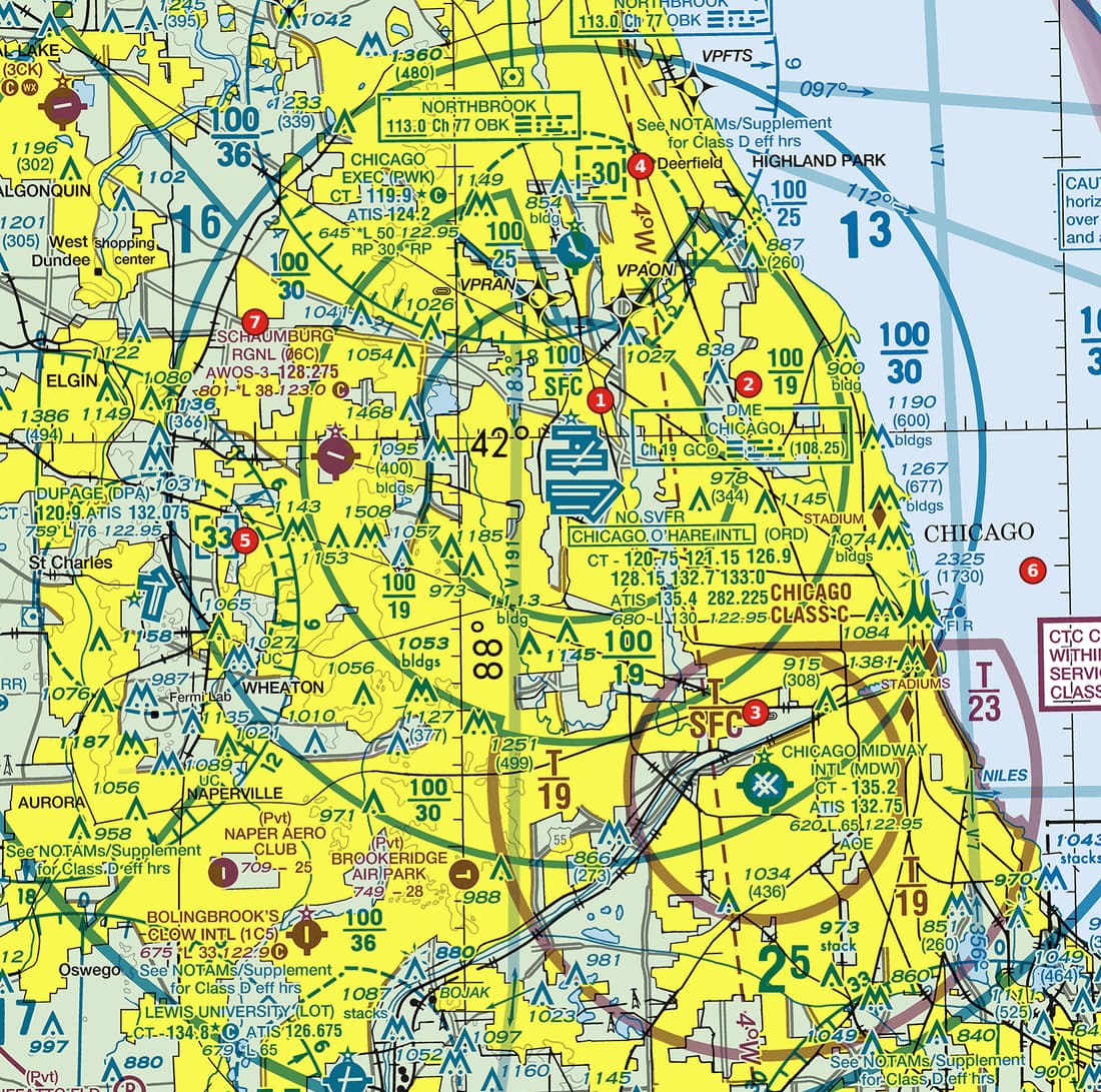 Open Figure 104, area 6 full size
Figure 104, area 6 Lakeside metropolitan Class B with two major airports, sector blocks, a Class C core and satellite Class D airports. Tap to zoom. Which figure of the obstruction label near area 6, 2325 (1730), is its height above the ground?
Show the answer
B. 1,730 ft. The figure in parentheses is the AGL height; 2,325 ft is the top above MSL and 595 ft the ground elevation.
Source: Chart User's Guide, VFR terms p. 11 (obstruction symbols: MSL top, AGL height in parentheses)
-
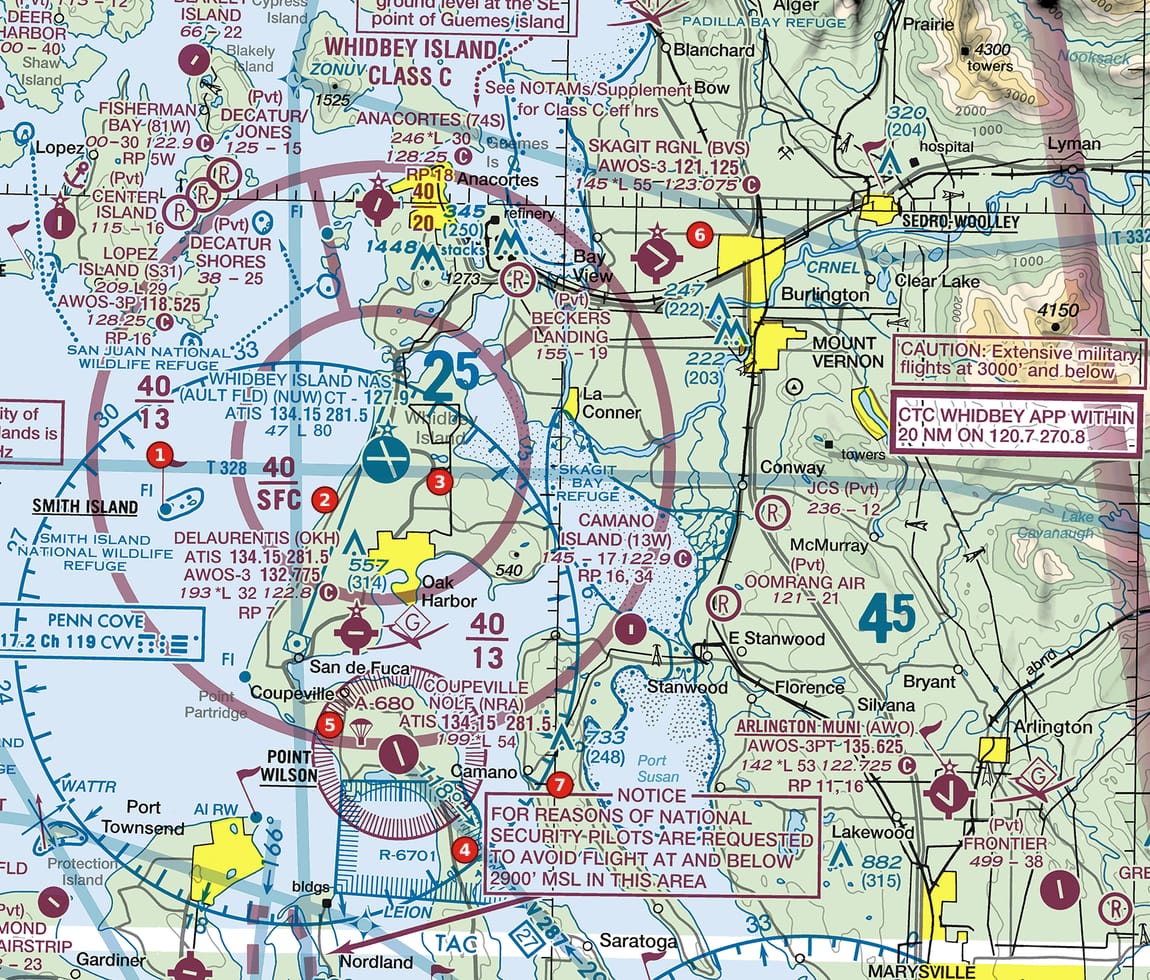 Open Figure 102, area 7 full size
Figure 102, area 7 Island Class C with sector blocks, a restricted area, an alert area and a national-security notice. Tap to zoom. Up and to the right of area 7 is an obstruction labelled 733 (248). A drone flies a mile away from it, with no other structure nearby. What is its maximum altitude under § 107.51(b)?
Show the answer
C. 400 ft AGL. The structure exception applies only within a 400-ft radius of the structure; a mile away the limit is 400 ft AGL.
Source: 14 CFR 107.51 (operating limitations: 400 ft AGL and the structure exception)
Common slips
- Taking the big number as the tower's height. The upper number is MSL; the height is in parentheses.
- Using the structure exception far from the structure. It applies only within a 400-ft radius, and only up to 400 ft above the top.
- Adding 400 to the MSL figure and calling it AGL. Keep the two units apart.
- Assuming every tower is charted. Structures of 200 ft AGL or less (299 ft in city tint) are often left off, new ones may be missing, and guy wires never show.
See where you stand on the whole test
Chart reading is one part of the Part 107 test. The free Muster Check covers all five test areas in the proportions the real test uses and shows the cited source for every answer.
More chart practice
- How to read Class B and Class C sector blocks
- Class D on a sectional chart: ceiling boxes and part-time towers
- Class E and Class G on a sectional: magenta vs blue shading and dashed magenta
- Maximum elevation figures (MEF) on a sectional chart
- Special use airspace and military training routes on a sectional chart
- How to read an airport data block on a sectional chart
- Do I need ATC authorization here? Reading the chart for Part 107
Chart excerpts: FAA VFR sectional charts (public domain), markers added. Rules: FAA Aeronautical Chart User's Guide, Aeronautical Information Manual, Remote Pilot Study Guide and 14 CFR part 107. Independent study tool. Not affiliated with or endorsed by the FAA.