Class E and Class G on a sectional: magenta vs blue shading and dashed magenta
Unless the chart shows otherwise, Class E starts at 1,200 ft AGL. A magenta vignette (a soft shaded band) marks an area where Class E starts lower, at 700 ft AGL; a blue vignette marks where a floor other than 700 ft meets uncontrolled airspace, typically 1,200 ft AGL. A dashed magenta line is different: Class E that starts at the surface around an airport, which needs ATC authorization for a drone. Below the Class E floor is Class G.
Last reviewed
The excerpts are cut from FAA sectional charts, edition effective October 29, 2026, with red numbered markers (areas) added by us. Sectional charts are updated every 56 days, so every reading below describes the excerpt as printed, not the chart you would buy today.
The legend rule
Class E exists at 1,200 ft AGL unless designated otherwise, and its limits below 18,000 ft are shown by narrow vignette bands. A magenta vignette defines controlled airspace with a floor of 700 ft above the ground; floors other than 700 ft that laterally abut Class G are defined by a blue vignette.
Source: Chart User's Guide, VFR terms p. 17 (Class E surface areas, vignettes, Class G); Chart User's Guide, sectional legend p. 27 (Class C, D and E symbols)
The AIM says the same of Class E transition areas: they extend upward from either 700 ft AGL (magenta vignette) or 1,200 ft AGL (blue vignette), and they stay in effect continuously, whatever the airport's hours.
Source: AIM 3-2-6 (Class E transition areas: 700 ft and 1,200 ft AGL)
A Class E surface area is drawn with a magenta dashed line. It extends upward from the surface around an airport; one that operates less than continuously carries a note, on these excerpts "See NOTAMs/Supplement for Class E (sfc) eff hrs". A part-time surface area can become Class G at other times.
Source: Chart User's Guide, VFR terms p. 17 (Class E surface areas, vignettes, Class G); AIM 3-2-6 (Class E surface areas)
Class G is the uncontrolled airspace from the surface up to the base of the overlying Class E. A remote pilot needs no ATC authorization in Class G, and in most cases none in Class E either. The exception is the surface area: § 107.41 requires prior authorization within the lateral boundaries of the surface area of Class E airspace designated for an airport.
Source: Remote Pilot Study Guide ch. 2 (Class G airspace); Remote Pilot Study Guide ch. 2 (Class E airspace); 14 CFR 107.41 (operation in certain airspace)
Worked examples
Example 1: Figure 103, area 1
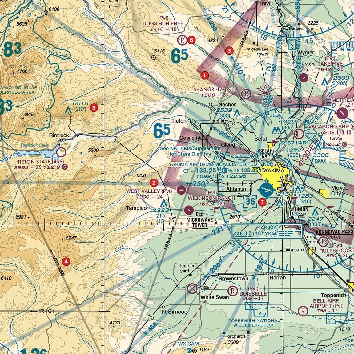
Area 1 sits on a soft magenta band north-west of the city (ignore the grey military route band that crosses it there; it is not an airspace boundary). Where does Class E begin on each side of the magenta band, and what does that mean for a drone at 400 ft AGL?
 Open Figure 103, area 1 full size
- The band is a magenta vignette: inside the area it marks, Class E begins at 700 ft AGL.
- Out in the unshaded mountains to the west, no vignette changes the default, so Class E begins at 1,200 ft AGL.
- Below either floor is Class G.
- A drone at 400 ft AGL is below both floors, so it is in Class G on either side of the band (no surface area is drawn here).
Reading: 700 ft AGL inside the shaded area, 1,200 ft AGL outside it; Class G below. At 400 ft AGL a drone is in Class G on both sides.
Source: Chart User's Guide, VFR terms p. 17 (Class E surface areas, vignettes, Class G); AIM 3-2-6 (Class E transition areas: 700 ft and 1,200 ft AGL); Remote Pilot Study Guide ch. 2 (Class G airspace)
Example 2: Figure 110, areas 2 and 1
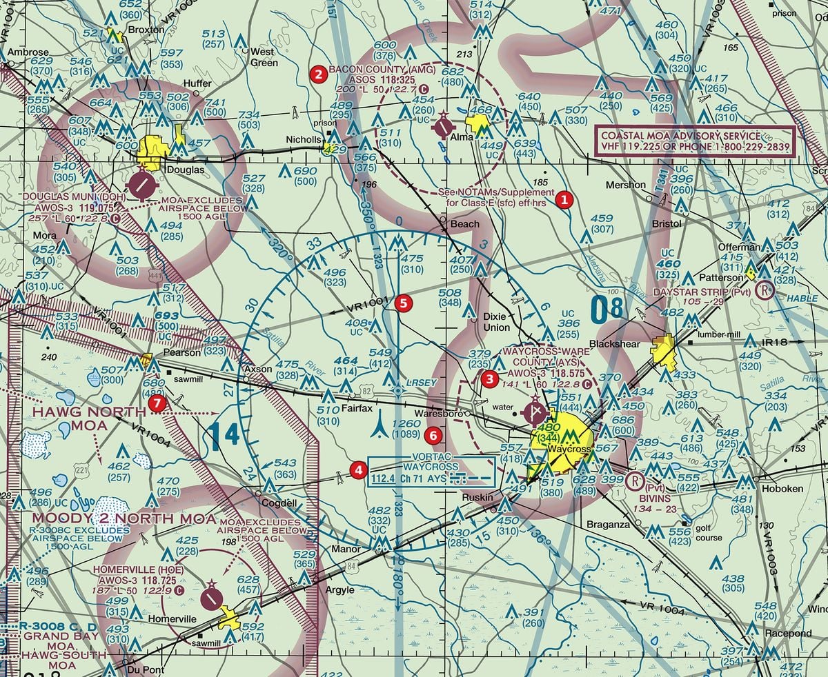
What is the dashed magenta circle around the Bacon County airport (area 2), and what does the note at area 1 add?
 Open Figure 110, areas 2 and 1 full size
- The airport symbol and data block are magenta: no control tower.
- The dashed magenta circle around it is a Class E surface area: controlled airspace from the surface up.
- The note at area 1 reads See NOTAMs/Supplement for Class E (sfc) eff hrs: the surface area is part-time, with its hours in NOTAMs and the Chart Supplement.
- Inside the circle, while the surface area is in effect, a drone needs prior ATC authorization (§ 107.41), tower or not.
Reading: A part-time Class E surface area at a non-towered airport. Inside it, during its hours, a drone needs ATC authorization.
Source: Chart User's Guide, VFR terms p. 17 (Class E surface areas, vignettes, Class G); Chart User's Guide, VFR terms p. 15 (towered airports in blue, others in magenta; lighting codes); AIM 3-2-6 (Class E surface areas); 14 CFR 107.41 (operation in certain airspace)
Example 3: Figure 110, area 3
The Waycross airport at area 3 has two magenta markings around it: a soft shaded ring and a dashed circle. What does each mean?
Open Figure 110, area 3 full size
- The dashed magenta circle: a Class E surface area, from the ground up. § 107.41 applies inside it.
- The soft magenta shading: Class E starting at 700 ft AGL across the area it marks. That one needs no authorization for a drone below 700 ft AGL, because the airspace beneath it is Class G.
- So the same airport has Class E at the surface close in, and Class G under a 700-ft floor further out.
Reading: Dashed circle: Class E from the surface (authorization needed). Shading: Class E from 700 ft AGL, with Class G below.
Source: Chart User's Guide, VFR terms p. 17 (Class E surface areas, vignettes, Class G); AIM 3-2-6 (Class E transition areas: 700 ft and 1,200 ft AGL); 14 CFR 107.41 (operation in certain airspace); Remote Pilot Study Guide ch. 2 (Class G airspace)
Check yourself
Three options each, as on the test. Pick one, then open the answer.
-
Open Figure 110, area 3 full size
Figure 110, area 3 Rural pine country with Class E surface areas at non-towered airports, a VORTAC, military training routes and towers. Tap to zoom. A remote pilot plans to fly at 200 ft AGL inside the dashed magenta circle around the airport at area 3. What applies?
Show the answer
B. Prior ATC authorization: it is a Class E surface area. A dashed magenta line is a Class E surface area, and § 107.41 requires prior authorization within it, towered airport or not.
Source: Chart User's Guide, VFR terms p. 17 (Class E surface areas, vignettes, Class G); 14 CFR 107.41 (operation in certain airspace)
-
Open Figure 103, area 1 full size
Figure 103, area 1 Mountain-edge valley with a Class D airport, Class E shading, private strips, obstructions and military training routes. Tap to zoom. In the area marked by the magenta shading at area 1, where does Class E airspace begin?
Show the answer
A. 700 ft AGL. A magenta vignette marks Class E with a floor of 700 ft above the ground.
Source: Chart User's Guide, VFR terms p. 17 (Class E surface areas, vignettes, Class G); AIM 3-2-6 (Class E transition areas: 700 ft and 1,200 ft AGL)
-
Open Figure 103, area 5 full size
Figure 103, area 5 Mountain-edge valley with a Class D airport, Class E shading, private strips, obstructions and military training routes. Tap to zoom. Area 5 is on a mountain ridge in the unshaded area west of the valley. What is the airspace from the surface up to 1,200 ft AGL there?
Show the answer
C. Class G. With no vignette or other boundary drawn, Class E starts at 1,200 ft AGL; the airspace below it is Class G.
Source: Chart User's Guide, VFR terms p. 17 (Class E surface areas, vignettes, Class G); Remote Pilot Study Guide ch. 2 (Class G airspace)
-
Open Figure 110, area 1 full size
Figure 110, area 1 Rural pine country with Class E surface areas at non-towered airports, a VORTAC, military training routes and towers. Tap to zoom. What does the note at area 1 tell you about the dashed magenta circle beside it?
Show the answer
A. The Class E surface area is part-time; its hours are in NOTAMs and the Chart Supplement. A Class E surface area operating less than continuously is marked with that note.
Source: Chart User's Guide, VFR terms p. 17 (Class E surface areas, vignettes, Class G); AIM 3-2-6 (Class E surface areas)
-
 Open Figure 105, area 6 full size
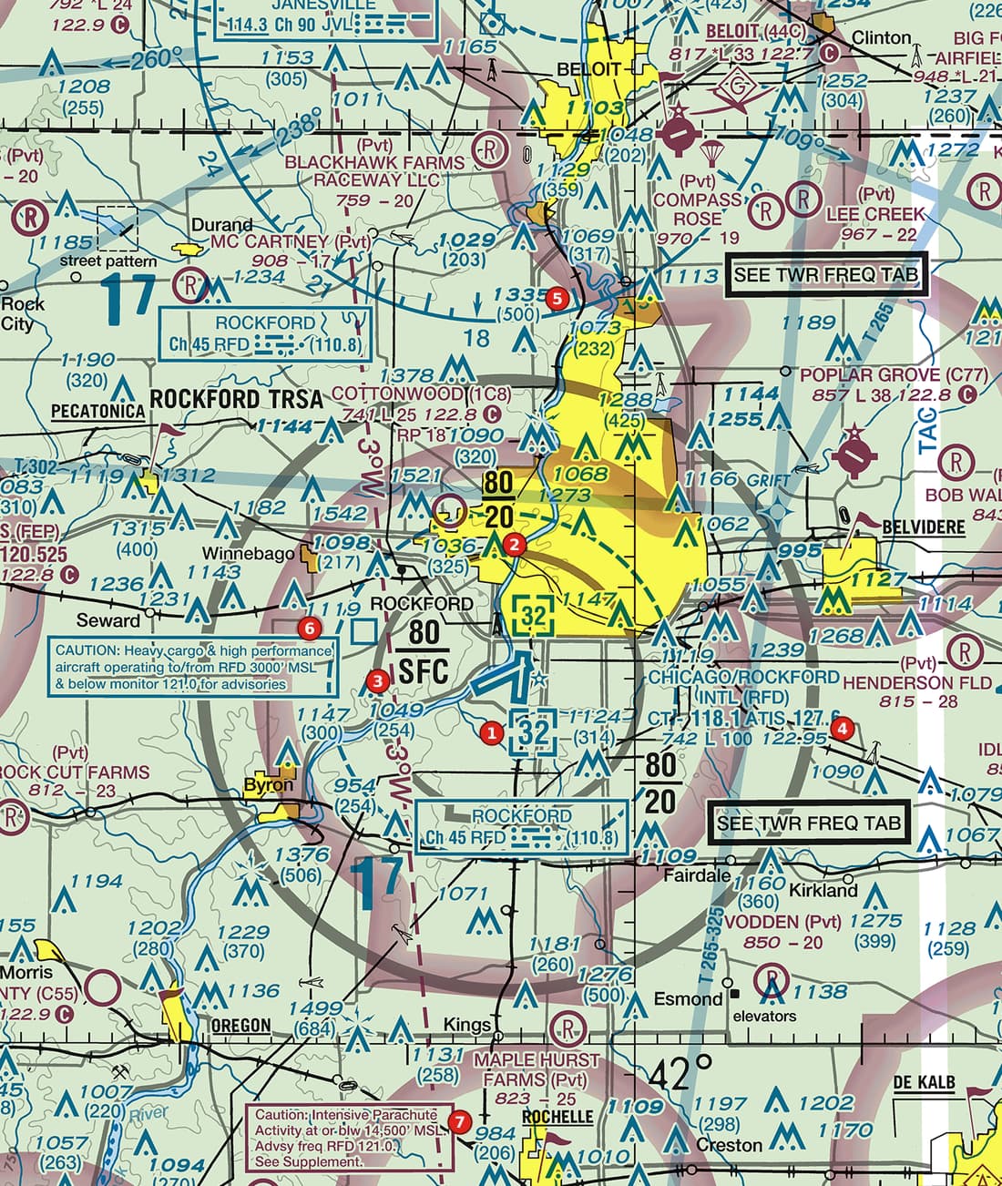
Figure 105, area 6 Prairie city with a Class D airport inside a terminal radar service area, Class E shading, many obstructions and caution notes. Tap to zoom. The soft magenta band beside area 6 runs around the city. What does it show?
Show the answer
B. Class E airspace beginning at 700 ft AGL. A magenta vignette marks a 700-ft AGL Class E floor. A surface area would be a dashed magenta line; a MOA has a hatched border and a name.
Source: Chart User's Guide, VFR terms p. 17 (Class E surface areas, vignettes, Class G); AIM 3-2-6 (Class E transition areas: 700 ft and 1,200 ft AGL)
Common slips
- Treating any magenta near an airport as surface Class E. Soft shading is a 700-ft floor; only the dashed magenta line starts at the surface.
- Forgetting the dashed magenta line needs authorization. § 107.41 covers Class E surface areas designated for an airport, even without a tower.
- Thinking a 700-ft floor matters at 400 ft AGL. Below it you are in Class G; the shading changes where Class E starts, not what a drone needs.
- Reading the vignette numbers as MSL. The 700 ft and 1,200 ft floors are above the ground.
See where you stand on the whole test
Chart reading is one part of the Part 107 test. The free Muster Check covers all five test areas in the proportions the real test uses and shows the cited source for every answer.
More chart practice
- How to read Class B and Class C sector blocks
- Class D on a sectional chart: ceiling boxes and part-time towers
- Obstruction heights on a sectional chart: MSL vs AGL and the 400-ft rule
- Maximum elevation figures (MEF) on a sectional chart
- Special use airspace and military training routes on a sectional chart
- How to read an airport data block on a sectional chart
- Do I need ATC authorization here? Reading the chart for Part 107
Chart excerpts: FAA VFR sectional charts (public domain), markers added. Rules: FAA Aeronautical Chart User's Guide, Aeronautical Information Manual, Remote Pilot Study Guide and 14 CFR part 107. Independent study tool. Not affiliated with or endorsed by the FAA.