Class D on a sectional chart: ceiling boxes and part-time towers
Class D is the dashed blue line around a towered airport. Its ceiling is the number in the dashed blue box, in hundreds of feet MSL, so [36] is 3,600 ft MSL; a minus sign in front, as in [-45], means from the surface up to, but not including, 4,500 ft MSL. A star after the tower frequency means the tower is part-time; when the Class D is not in effect, the surface area becomes Class E or Class G, as published in the Chart Supplement.
Last reviewed
The excerpts are cut from FAA sectional charts, edition effective October 29, 2026, with red numbered markers (areas) added by us. Sectional charts are updated every 56 days, so every reading below describes the excerpt as printed, not the chart you would buy today.
The legend rule
Class D airspace is identified with a blue dashed line. Its ceiling is shown in a box, with the altitude in hundreds of feet MSL, and a minus in front of the figure means "from surface to, but not including" that altitude.
Source: Chart User's Guide, VFR terms p. 16 (Class D boundary, ceilings and part-time note); Chart User's Guide, sectional legend p. 27 (Class C, D and E symbols)
Class D is generally from the surface to 2,500 ft above the airport elevation (charted in MSL) around airports with an operational control tower, so the box is usually close to the field elevation plus 2,500.
Source: Remote Pilot Study Guide ch. 2 (Class D airspace); AIM 3-2-5 (Class D airspace; part-time surface areas)
In the airport data block, a star after the control tower (CT) frequency means the tower operates part-time; the tower frequencies tabulation gives the hours. A Class D that is not continuous carries a note, on these excerpts "See NOTAMs/Supplement for Class D eff hrs".
Source: Chart User's Guide, VFR terms p. 15 (airport data: elevation, runway length, CT, star, CTAF); Chart User's Guide, VFR terms p. 16 (Class D boundary, ceilings and part-time note)
When a part-time Class D surface area is not in effect, it reverts to either a Class E surface area or Class G airspace; the Chart Supplement entry says which ("other times CLASS E" or "other times CLASS G").
Source: AIM 3-2-5 (Class D airspace; part-time surface areas); AIM 3-2-5 (Class D when the tower is closed)
For a drone, Class D needs prior ATC authorization, and so does a Class E surface area designated for an airport. A part-time Class D that reverts to Class E surface still needs authorization; only a reversion to Class G removes it.
Source: 14 CFR 107.41 (operation in certain airspace); AIM 3-2-5 (Class D airspace; part-time surface areas)
Worked examples
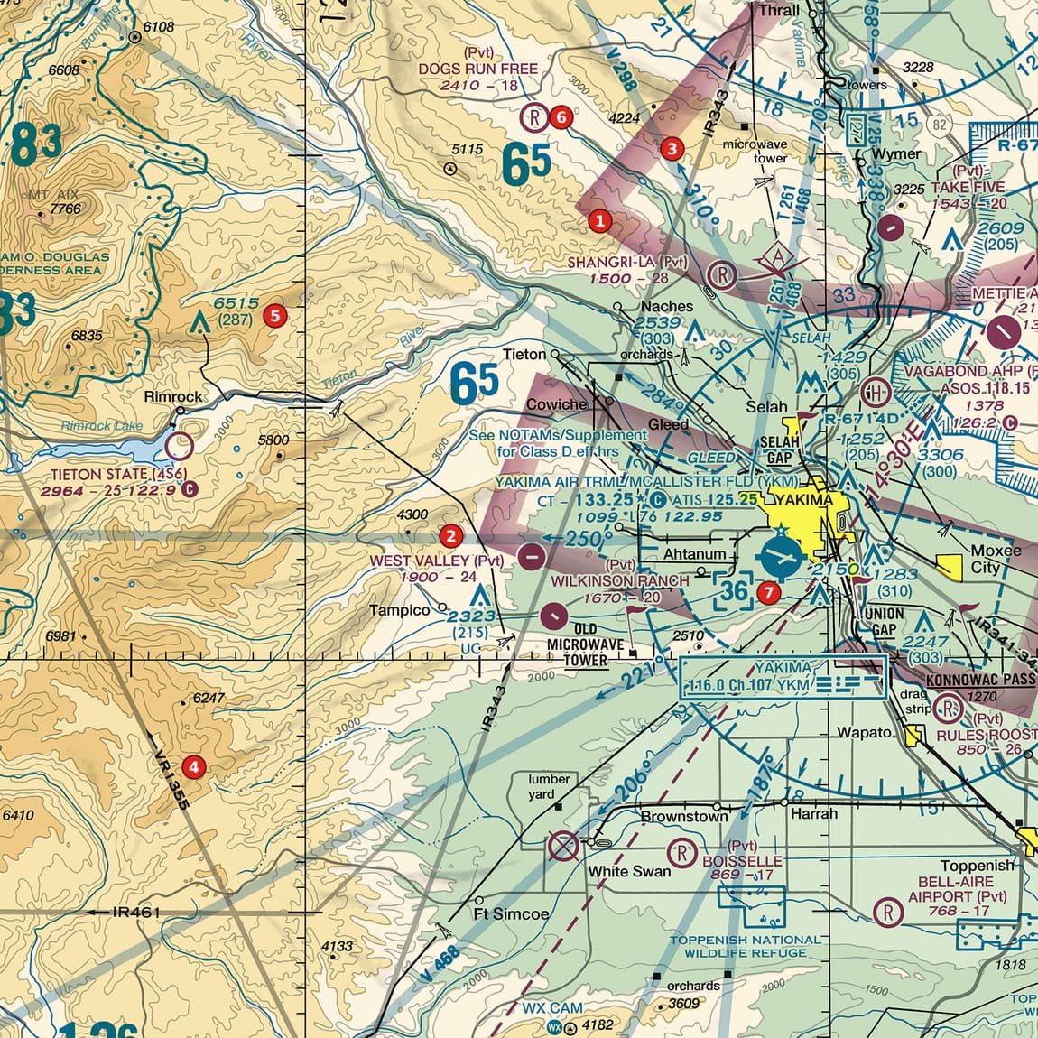
Example 1: Figure 103, area 7
What is the Class D ceiling at area 7, and how does it compare with the airport's elevation?
 Open Figure 103, area 7 full size
- The dashed blue box beside area 7 reads 36: the Class D ceiling is 3,600 ft MSL.
- The airport's data block (YAKIMA AIR TRML/MCALLISTER FLD, up and to the left) has the line 1099 *L 76 122.95. Its opening figure is the field elevation: 1,099 ft.
- 3,600 - 1,099 = 2,501 ft, about 2,500 ft above the field, the usual Class D height.
- The same block reads CT - 133.25 with a star, and a note nearby says See NOTAMs/Supplement for Class D eff hrs: the tower is part-time.
Reading: Ceiling 3,600 ft MSL, about 2,500 ft above the 1,099-ft field; the Class D is part-time.
Source: Chart User's Guide, sectional legend p. 27 (Class C, D and E symbols); Remote Pilot Study Guide ch. 2 (Class D airspace); Chart User's Guide, VFR terms p. 15 (airport data: elevation, runway length, CT, star, CTAF); Chart User's Guide, VFR terms p. 16 (Class D boundary, ceilings and part-time note)
Example 2: Figure 106, areas 3 and 1
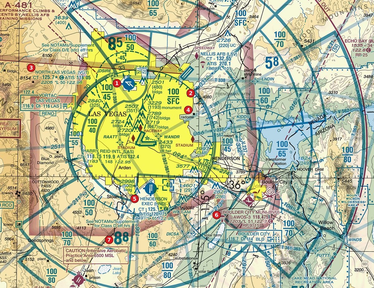
The North Las Vegas airport (data block at area 3) has the ceiling box [-45] above its symbol. What does the minus mean here?
 Open Figure 106, areas 3 and 1 full size
- The box reads -45: Class D from the surface up to, but not including, 4,500 ft MSL.
- The Class B block beside area 1, over the same airport, reads 100 over 45: Class B starts at 4,500 ft MSL.
- So the Class D stops just below the Class B floor; the two do not overlap.
- The data block also shows CT - 125.7 with a star, and the note above it reads See NOTAMs/Supplement for Class D/E (sfc) eff hrs: part-time.
Reading: Surface up to, but not including, 4,500 ft MSL, where the Class B above begins. Part-time tower.
Source: Chart User's Guide, VFR terms p. 16 (Class D boundary, ceilings and part-time note); Chart User's Guide, VFR terms p. 16 (right traffic; Class B and Class C altitudes); Chart User's Guide, VFR terms p. 15 (airport data: elevation, runway length, CT, star, CTAF)
Example 3: Figure 108, areas 4 and 5
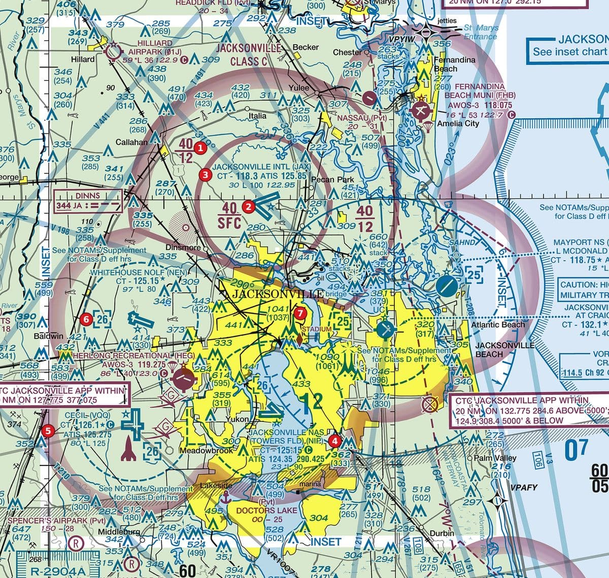
Both airports at areas 4 and 5 sit inside dashed blue circles with [26] boxes. Which tower is part-time?
 Open Figure 108, areas 4 and 5 full size
- Area 5 (CECIL): CT - 126.1 is followed by a star. Part-time tower; a note beside it reads See NOTAMs/Supplement for Class D eff hrs.
- Area 4 (JACKSONVILLE NAS): CT - 125.15 has no star after it.
- Both ceilings read 26: 2,600 ft MSL.
Reading: Cecil (area 5) is part-time; the area 4 tower shows no star. Both Class D ceilings are 2,600 ft MSL.
Source: Chart User's Guide, VFR terms p. 15 (airport data: elevation, runway length, CT, star, CTAF); Chart User's Guide, VFR terms p. 16 (Class D boundary, ceilings and part-time note); Chart User's Guide, sectional legend p. 27 (Class C, D and E symbols)
Check yourself
Three options each, as on the test. Pick one, then open the answer.
-
 Open Figure 104, area 5 full size
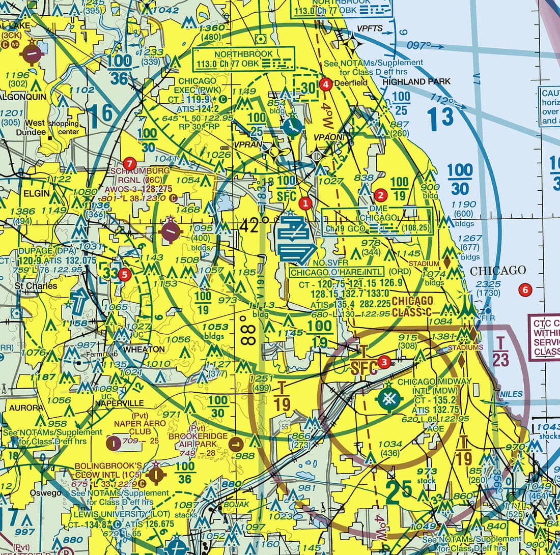
Figure 104, area 5 Lakeside metropolitan Class B with two major airports, sector blocks, a Class C core and satellite Class D airports. Tap to zoom. What is the ceiling of the Class D airspace shown by the box next to area 5?
Show the answer
C. 3,300 ft MSL. The dashed blue box reads 33: a Class D ceiling in hundreds of feet MSL.
Source: Chart User's Guide, sectional legend p. 27 (Class C, D and E symbols); Chart User's Guide, VFR terms p. 16 (Class D boundary, ceilings and part-time note)
-
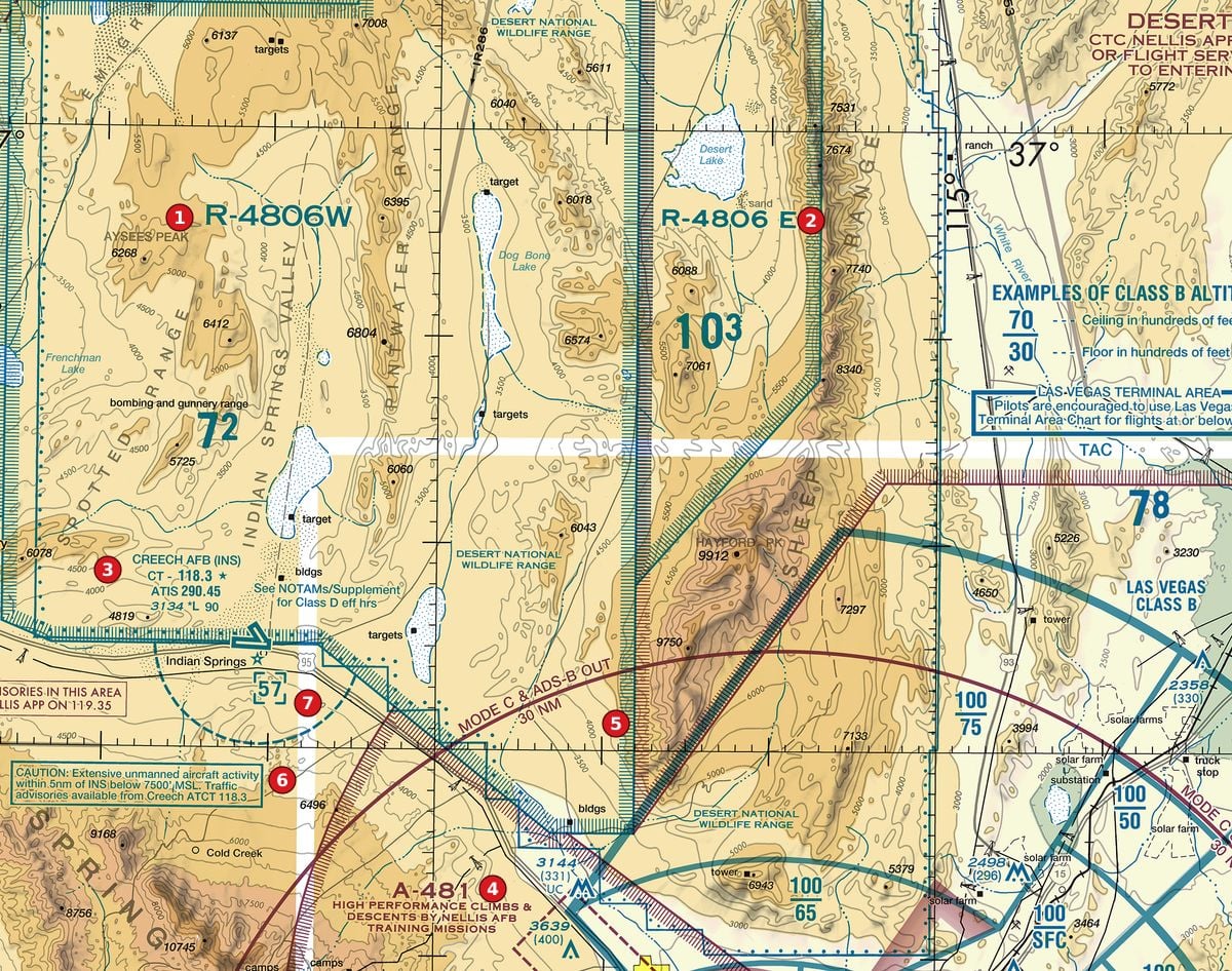 Open Figure 107, area 7 full size
Figure 107, area 7 Restricted areas and an alert area on the edge of a military range, with a military airport. Tap to zoom. What is the ceiling of the Class D airspace marked by the box at area 7?
Show the answer
A. 5,700 ft MSL. The box reads 57: 5,700 ft MSL. With the field elevation of 3,134 ft (data block at area 3), that is about 2,566 ft above the airport.
Source: Chart User's Guide, sectional legend p. 27 (Class C, D and E symbols)
-
Open Figure 106, area 5 full size
Figure 106, area 5 Desert metropolitan area with Class B sector blocks, satellite Class D airports and obstructions. Tap to zoom. Beside the Henderson airport's data block at area 5 is a box reading -40. What does it mean?
Show the answer
B. Class D from the surface up to, but not including, 4,000 ft MSL. A minus in front of a Class D ceiling means from the surface to, but not including, that altitude, in hundreds of feet MSL.
Source: Chart User's Guide, VFR terms p. 16 (Class D boundary, ceilings and part-time note); Chart User's Guide, sectional legend p. 27 (Class C, D and E symbols)
-
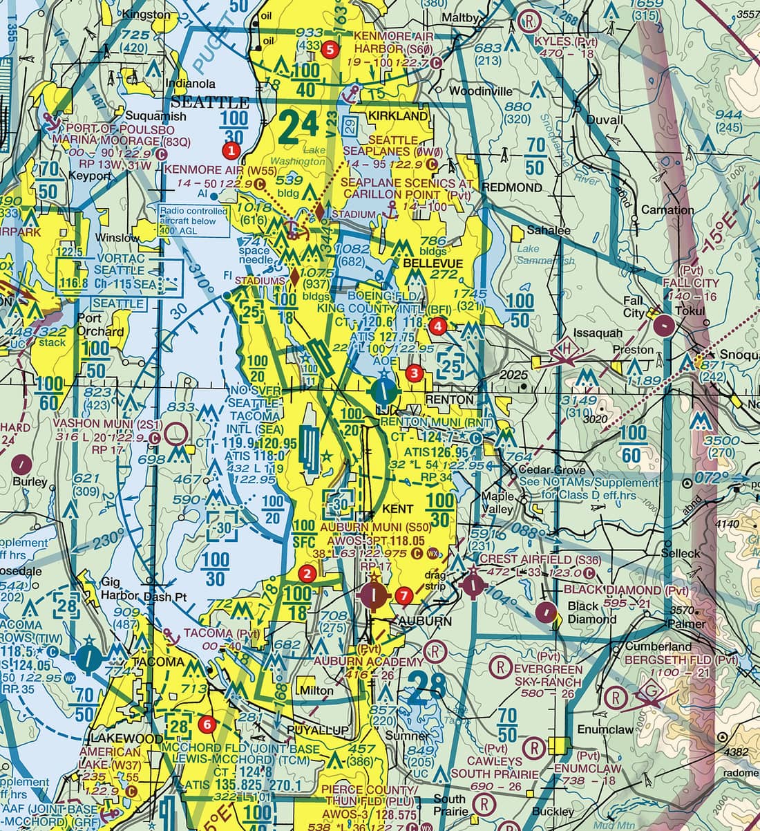 Open Figure 101, area 3 full size
Figure 101, area 3 Coastal metropolitan area with Class B sector blocks, satellite Class D airports and a seaplane base. Tap to zoom. The Renton airport's data block at area 3 reads CT - 124.7 followed by a star. What does that star tell you?
Show the answer
A. The control tower operates part-time. A star after the CT frequency means part-time operation (hours in the tower frequencies tabulation). The beacon is a star on the airport symbol itself, not after a frequency.
Source: Chart User's Guide, VFR terms p. 15 (airport data: elevation, runway length, CT, star, CTAF); Chart User's Guide, VFR terms p. 15 (towered airports in blue, others in magenta; lighting codes)
-
Open Figure 108, area 6 full size
Figure 108, area 6 River city with Class C sector blocks, several Class D airports and tall obstructions. Tap to zoom. The Class D at area 6 carries the note See NOTAMs/Supplement for Class D eff hrs. What does that tell a remote pilot?
Show the answer
C. The Class D is part-time; its hours are in the Chart Supplement and NOTAMs. That note marks a Class D operating less than continuously. At other times the surface area becomes Class E or Class G, as the Chart Supplement states.
Source: Chart User's Guide, VFR terms p. 16 (Class D boundary, ceilings and part-time note); AIM 3-2-5 (Class D airspace; part-time surface areas)
Common slips
- Reading the box as AGL. [26] is 2,600 ft MSL; subtract the field elevation for height above the airport.
- Ignoring the minus. [-45] stops just short of 4,500 ft MSL, usually where other airspace takes over.
- Mixing up the two stars. A star after the tower frequency means part-time; a star on the airport symbol is the beacon.
- Assuming a closed tower means no authorization. If the surface area reverts to Class E, § 107.41 still applies; only Class G removes the requirement.
See where you stand on the whole test
Chart reading is one part of the Part 107 test. The free Muster Check covers all five test areas in the proportions the real test uses and shows the cited source for every answer.
More chart practice
- How to read Class B and Class C sector blocks
- Class E and Class G on a sectional: magenta vs blue shading and dashed magenta
- Obstruction heights on a sectional chart: MSL vs AGL and the 400-ft rule
- Maximum elevation figures (MEF) on a sectional chart
- Special use airspace and military training routes on a sectional chart
- How to read an airport data block on a sectional chart
- Do I need ATC authorization here? Reading the chart for Part 107
Chart excerpts: FAA VFR sectional charts (public domain), markers added. Rules: FAA Aeronautical Chart User's Guide, Aeronautical Information Manual, Remote Pilot Study Guide and 14 CFR part 107. Independent study tool. Not affiliated with or endorsed by the FAA.