Maximum elevation figures (MEF) on a sectional chart
The large blue numbers with a smaller raised digit, such as 8⁸, are Maximum Elevation Figures. Read the big digit or digits as thousands and the small one as hundreds: 8⁸ is 8,800 ft MSL. An MEF is the highest elevation in that quadrangle, terrain or man-made obstacle, with allowances for error and rounded up, so it is an MSL height for the whole box, not the ground where you stand and not a drone altitude limit.
Last reviewed
The excerpts are cut from FAA sectional charts, edition effective October 29, 2026, with red numbered markers (areas) added by us. Sectional charts are updated every 56 days, so every reading below describes the excerpt as printed, not the chart you would buy today.
The legend rule
The Maximum Elevation Figure represents the highest elevation within a quadrangle, including terrain and other vertical obstacles (towers, trees and so on). On Sectionals a quadrangle is bounded by the ticked lines every 30 minutes of latitude and longitude. MEFs are rounded up to the nearest 100 ft, and the last two digits are not shown.
Source: Chart User's Guide, VFR terms p. 12 (Maximum Elevation Figures)
When a man-made obstacle is more than 200 ft above the highest terrain, the FAA takes the elevation of its top, adds the possible vertical error of the source (100 ft in the guide's example) and raises the result to the next 100 ft. When natural terrain is highest, it also adds a 200-ft allowance for uncharted obstacles before rounding up.
Source: Chart User's Guide, VFR terms p. 12 (Maximum Elevation Figures); Chart User's Guide, VFR terms p. 13 (MEF for natural terrain)
MEFs are not verified by field surveys, and the chart edition matters: check that your chart has the latest MEF data.
Source: Chart User's Guide, VFR terms p. 13 (MEF for natural terrain); AIM 5-1-1 (sectional charts updated every 56 days); Chart User's Guide, sectional legend p. 23 (charts updated every 56 days)
For a drone, the altitude limit is measured from the ground: 400 ft AGL, with the structure exception. An MEF is an MSL figure for a whole quadrangle, so it is a warning about what stands somewhere in the box, not a ceiling for your flight.
Source: 14 CFR 107.51 (operating limitations: 400 ft AGL and the structure exception); Chart User's Guide, VFR terms p. 12 (Maximum Elevation Figures)
Worked examples
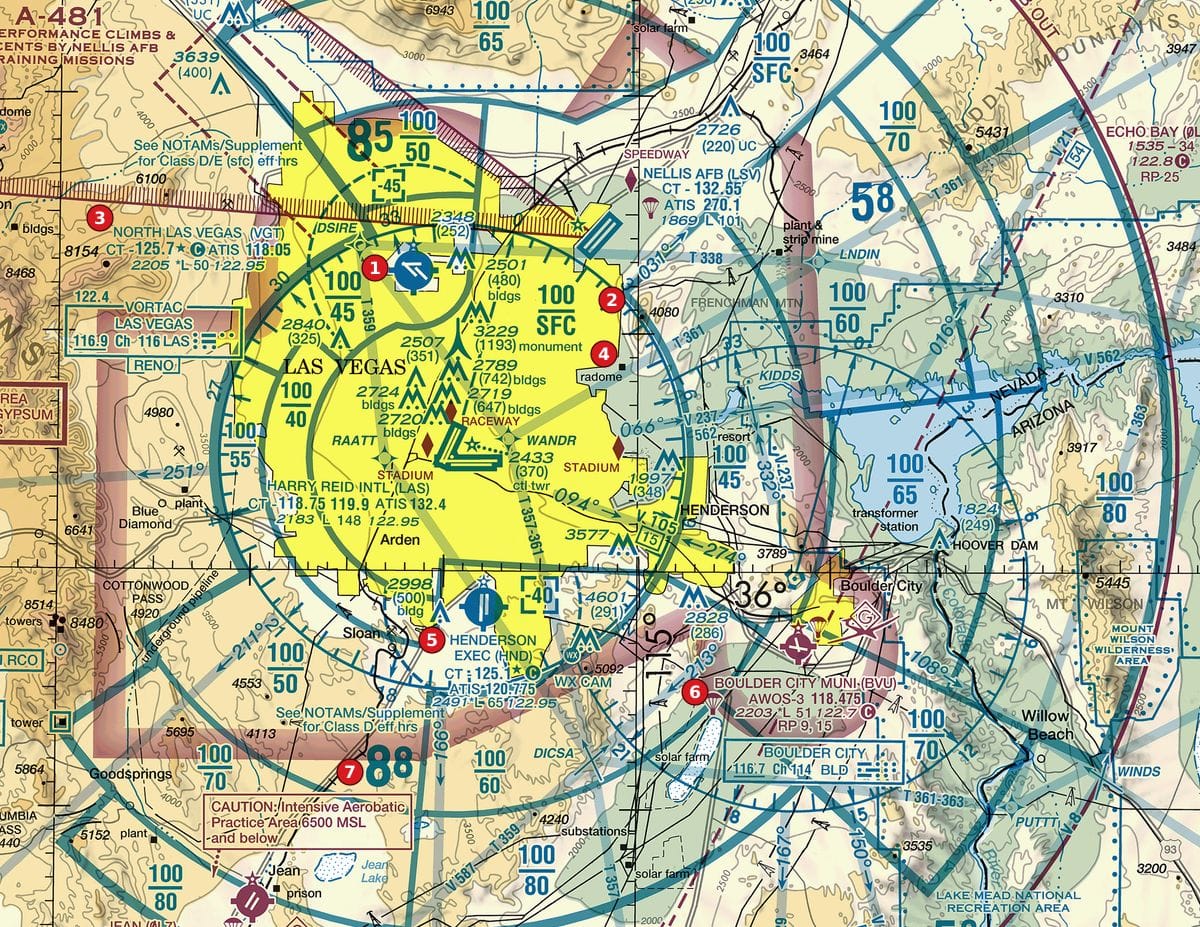
Example 1: Figure 106, area 7
Read the MEF at area 7.
 Open Figure 106, area 7 full size
- Beside area 7 is a large blue 8 followed by a smaller raised 8: 8⁸.
- Big digit = thousands, small digit = hundreds: 8,800 ft MSL.
- Meaning: nothing in that quadrangle, terrain or obstacle, should top about 8,800 ft MSL, after the allowances and rounding.
Reading: 8,800 ft MSL, the maximum elevation figure for that quadrangle.
Source: Chart User's Guide, VFR terms p. 12 (Maximum Elevation Figures)
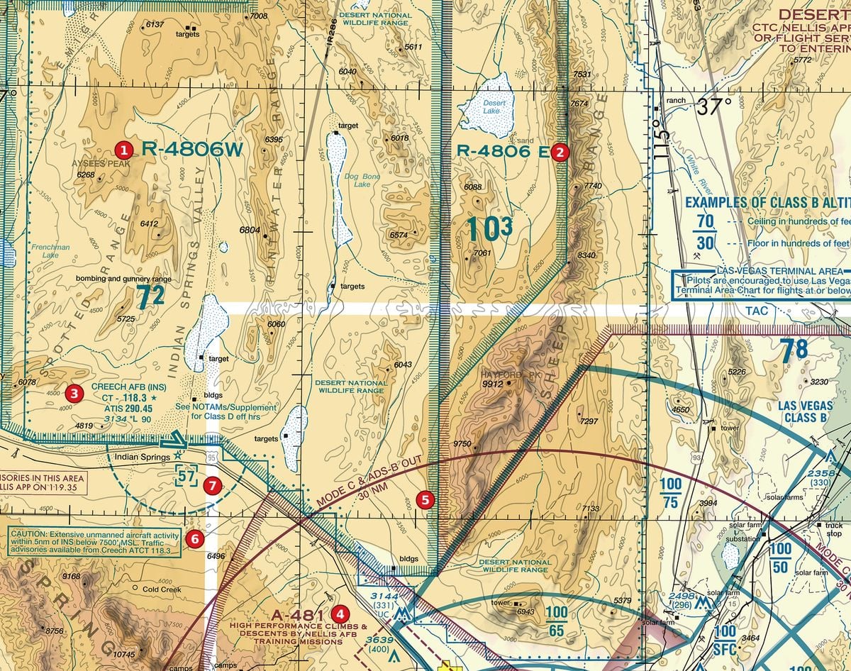
Example 2: Figure 107, MEF 10³ below area 2
Below area 2, inside the restricted area, is a large 10³. Hayford Peak (9912) sits further south between the same ticked grid lines. How do the two fit together?
 Open Figure 107, MEF 10³ below area 2 full size
- 10³ reads as 10,300 ft MSL.
- The highest charted point near it is the spot elevation HAYFORD PK 9912.
- With the guide's natural-terrain allowances: 9,912 + 100 + 200 = 10,212 ft, which rounds up to the next 100 ft: 10,300.
- That matches the printed figure, which is why the MEF sits roughly 400 ft above the peak.
Reading: 10,300 ft MSL: the highest terrain plus the error and obstacle allowances, rounded up.
Source: Chart User's Guide, VFR terms p. 13 (MEF for natural terrain); Chart User's Guide, VFR terms p. 12 (Maximum Elevation Figures)
Example 3: Figure 103, area 6
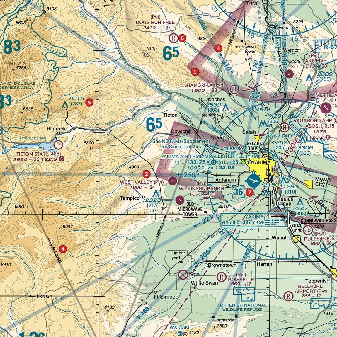
Area 6 marks a private airstrip, DOGS RUN FREE, labelled 2410 - 18. Just right of it is a large 6⁵. Does the MEF describe the airstrip?
 Open Figure 103, area 6 full size
- The airstrip's opening figure is its elevation: 2,410 ft.
- 6⁵ reads as 6,500 ft MSL.
- The MEF covers the highest point anywhere in the quadrangle, here the mountains, not the spot you are standing on: 6,500 - 2,410 = 4,090 ft above the strip.
Reading: No. The MEF (6,500 ft MSL) is for the whole quadrangle; the strip itself is at 2,410 ft.
Source: Chart User's Guide, VFR terms p. 12 (Maximum Elevation Figures); Chart User's Guide, VFR terms p. 15 (airport data: elevation, runway length, CT, star, CTAF)
Check yourself
Three options each, as on the test. Pick one, then open the answer.
-
Open Figure 106, area 7 full size
Figure 106, area 7 Desert metropolitan area with Class B sector blocks, satellite Class D airports and obstructions. Tap to zoom. What does the figure 8⁸ beside area 7 mean?
Show the answer
C. 8,800 ft MSL. An MEF is in feet MSL with the last two digits left off: 8⁸ is 8,800 ft MSL.
Source: Chart User's Guide, VFR terms p. 12 (Maximum Elevation Figures)
-
Open Figure 107, MEF 7² below area 1 full size
Figure 107, MEF 7² below area 1 Restricted areas and an alert area on the edge of a military range, with a military airport. Tap to zoom. Below area 1, beside the words bombing and gunnery range, is a large 7². What is it?
Show the answer
A. A maximum elevation figure of 7,200 ft MSL. Big digit thousands, small digit hundreds, in feet MSL: 7,200 ft.
Source: Chart User's Guide, VFR terms p. 12 (Maximum Elevation Figures)
-
Open Figure 103, area 6 full size
Figure 103, area 6 Mountain-edge valley with a Class D airport, Class E shading, private strips, obstructions and military training routes. Tap to zoom. A remote pilot at the airstrip at area 6 sees the 6⁵ beside it. What does that figure mean for the flight?
Show the answer
B. Nothing in the quadrangle should exceed about 6,500 ft MSL; the drone limit is still 400 ft AGL. An MEF is the highest elevation in the quadrangle, in MSL. The § 107.51(b) limit is measured from the ground.
Source: Chart User's Guide, VFR terms p. 12 (Maximum Elevation Figures); 14 CFR 107.51 (operating limitations: 400 ft AGL and the structure exception)
-
 Open Figure 110, MEF 0⁸ up and right of area 3 full size
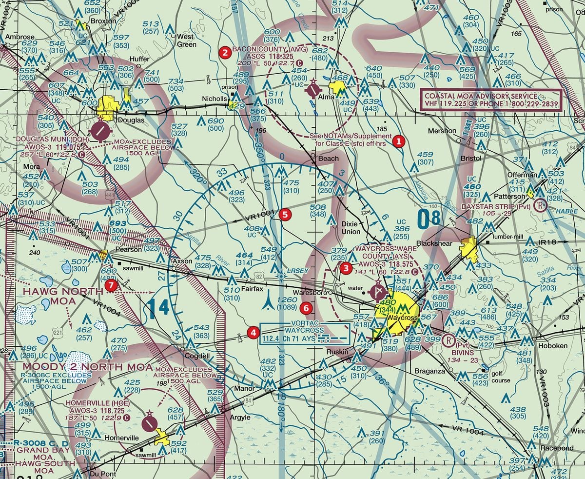
Figure 110, MEF 0⁸ up and right of area 3 Rural pine country with Class E surface areas at non-towered airports, a VORTAC, military training routes and towers. Tap to zoom. Up and to the right of area 3, near Blackshear, is a large 0⁸. What can you conclude?
Show the answer
C. No terrain or obstacle in that quadrangle is expected above about 800 ft MSL. 0⁸ is an MEF of 800 ft MSL: the highest elevation in the quadrangle, rounded up. It says nothing about AGL heights or drone limits.
Source: Chart User's Guide, VFR terms p. 12 (Maximum Elevation Figures)
Common slips
- Reading 8⁸ as 88 or 880. The small digit is hundreds: 8,800 ft.
- Treating the MEF as AGL. It is MSL, like terrain elevations.
- Using it as the ground height at a spot. It is the highest point in the whole quadrangle, plus allowances.
- Taking it as a drone ceiling. The limit is 400 ft AGL (with the structure exception).
See where you stand on the whole test
Chart reading is one part of the Part 107 test. The free Muster Check covers all five test areas in the proportions the real test uses and shows the cited source for every answer.
More chart practice
- How to read Class B and Class C sector blocks
- Class D on a sectional chart: ceiling boxes and part-time towers
- Class E and Class G on a sectional: magenta vs blue shading and dashed magenta
- Obstruction heights on a sectional chart: MSL vs AGL and the 400-ft rule
- Special use airspace and military training routes on a sectional chart
- How to read an airport data block on a sectional chart
- Do I need ATC authorization here? Reading the chart for Part 107
Chart excerpts: FAA VFR sectional charts (public domain), markers added. Rules: FAA Aeronautical Chart User's Guide, Aeronautical Information Manual, Remote Pilot Study Guide and 14 CFR part 107. Independent study tool. Not affiliated with or endorsed by the FAA.